 Hurricane Lee rapidly intensified into a scale-topping Category 5 storm on Thursday night, leap-frogging its way into the upper echelon of Atlantic hurricane history after an astounding bout of strengthening.
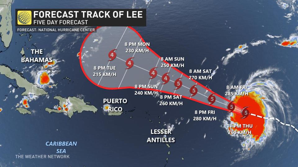
Forecasters expect Lee to maintain its tremendous strength for the next several days, likely remaining an intense major hurricane through at least early next week.
Visit The Weather Network’s hurricane hub to keep up with the latest on tropical developments in Canada and around the world
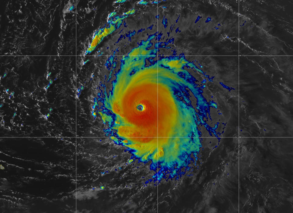
Lee underwent rapid intensification during the day Thursday. The storm packed maximum sustained winds of 260 km/h at 11:00 p.m. EDT, making it a rare Category 5 on the Saffir-Simpson Hurricane Wind Scale.

Given its textbook appearance on satellite imagery and the extremely favourable environment around the storm, the U.S. National Hurricane Center (NHC) upgraded Lee to a Category 5 on Thursday night, just 30 hours after it first became a hurricane.
MUST SEE: How a mammoth hurricane rapidly intensifies in mere hours
The hurricane’s maximum winds jumped 95 km/h in just 12 hours, and it strengthened by 130 km/h over the course of 24 hours. Lee will very likely rank among the most extreme cases of rapid intensification on record during the satellite era.
A Hurricane Hunter flight through the storm’s eye found that it continued its explosive strengthening trend through the day. Satellite imagery revealed the storm’s near-perfect appearance and a large, clear eye, both of which allowed it to power toward the top tier of all hurricanes ever recorded over the Atlantic Ocean.
DON’T MISS: How hot water fuels the world’s most powerful hurricanes
Hurricane Lee is only the 29th storm in the Atlantic Ocean to achieve this scale-topping intensity since the beginning of the satellite era in 1960. Eight of those Category 5 storms have formed in the past decade alone, the most recent of which before Lee was Hurricane Ian off the coast of Florida in September 2022.
The storm will maintain its powerful stature through at least early next week as it steadily moves west-northwest into the western Atlantic Ocean, passing north of the Lesser Antilles this weekend.
“Lee is forecast to remain a dangerous category 4 or 5 hurricane for the next 5 days,” the NHC said on Thursday night.
WATCH: The best time to prepare for a hurricane is long before one threatens. Here’s how
Watch, wait, and prepare for the peak of hurricane season
Coastal residents should closely monitor the progress of Hurricane Lee heading into next week.
It’s still far too early to predict how and if this hurricane will directly affect parts of the eastern seaboard of the United States and Canada in the next 7+ days.
There are lots of dynamic features that will affect Lee’s eventual path, and small changes could have a large effect on its path. It’s also important to note that Lee would not be at its peak strength if it affects land next week.
STAY SAFE: What you need in your hurricane preparedness kit
We’re now in the climatological peak of hurricane season across the Atlantic basin. Anyone along or near the East Coast should prepare for hazards like power outages and flooding regardless of this one storm’s progress.
Ensure you’ve got non-perishable food, water, personal hygiene supplies, flashlights, and batteries to last for several days without electricity or water. Prepare an emergency plan in case of flooding or evacuations.
Anxiety is normal when there’s a big storm out there, and even more so when the storm’s future is uncertain. Preparing for a storm now—long before one ever draws near—ensures you’ll be ready to go if anything looms on the horizon in the weeks and months ahead.
Stay with The Weather Network for the duration of this storm as we closely monitor this hurricane and its developments.
Header satellite image courtesy of NOAA.
WATCH: The relationship between hurricane strength and ocean temperatures
*****
Credit belongs to : ca.news.yahoo.com