 Visit The Weather Network’s hurricane hub to keep up with the latest on tropical developments in Canada and around the world
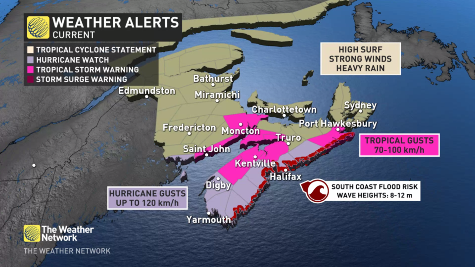
Widespread tropical storm warnings and hurricane watches are now in effect across portions of Nova Scotia and New Brunswick expecting hazardous conditions as Hurricane Lee approaches the area beginning late Friday night and peaking through the day Saturday.
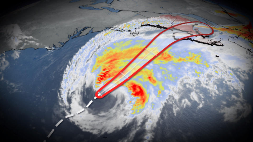
As expected, Lee is expanding in size but has started to weaken as it pushes through cooler waters. While further weakening is expected, Lee is likely to remain a “large and dangerous hurricane into the weekend,” says the U.S. National Hurricane Center (NHC).
The footprint of Hurricane Lee’s tropical storm-force winds extended a whopping 520 km from the centre of the storm by Thursday evening, and its hurricane-force winds reached 165 km from the centre of the storm.
On the forecast track, the centre of Lee will continue to move farther away from Bermuda Friday morning and approach the coast of New England and Atlantic Canada later in the day and Saturday. Lee is then expected to turn toward the north-northeast and northeast and move across Atlantic Canada Saturday night and Sunday.
WATCH: Tropical storm warnings, hurricane watches in effect across Maritimes
The hurricane weakened to a Category 1 hurricane on Thursday with maximum sustained winds of 140 km/h. It will continue to lose strength as it tracks north toward Atlantic Canada.
Despite Lee’s maximum winds falling, the storm’s sprawling footprint is important for any communities in its path. Lower maximum winds does not mean a lower overall threat from this storm.
 A threat for heavy rains, high winds, and coastal flooding will extend hundreds of kilometres from the centre of the storm. The biggest concerns will be dangerous surf and coastal flooding, especially during high tide.
As a result of these potential hazards, the Canadian Hurricane Centre (CHC) issued a tropical storm warning for the following areas in Nova Scotia:
- Annapolis County
- Colchester County – Cobequid Bay
- Cumberland County – Minas Shore
- Halifax Metro and Halifax County West
- Halifax County – east of Porters Lake
- Digby County
- Guysborough County
- Hants County
- Kings County
- Lunenburg County
- Queens County
- Shelburne County
- Yarmouth County
A tropical storm warning is also in effect for the following areas in New Brunswick:
- Fundy National Park
- Grand Manan and coastal Charlotte County
- Moncton and Southeast New Brunswick
- Saint John and County
In addition to the tropical storm warnings, a hurricane watch is in effect for Halifax Metro and Halifax County West, Halifax County – east of Porters Lake, Digby, Queens, Shelburne, and Yarmouth Counties in Nova Scotia, as well as Grand Manan and coastal Charlotte County in New Brunswick, for the potential for near-hurricane conditions during the height of the storm on Saturday.
Click here to stay up-to-date with the latest watches and warnings.
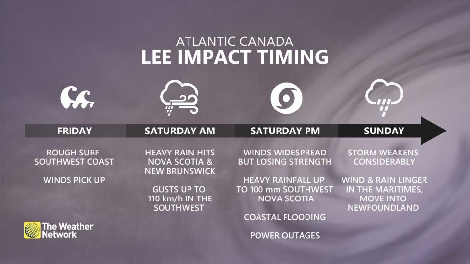
Strongest impacts expected Saturday
The CHC says this will be a Saturday event for the strongest impacts, with lingering impacts expected on Sunday across the Maritimes as the storm weakens and moves away.
 Lee is expected to transform into a post-tropical low while making landfall anywhere from Grand Manan Island New Brunswick to Shelburne County Nova Scotia Saturday evening. It is still expected to be a large and powerful system with impacts extending well away from the storm centre.
RAIN
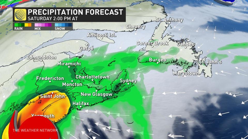
Lee’s outer rain bands and gusty winds will push into the Maritimes on Saturday morning, with conditions deteriorating through the day as the bulk of the system moves in.
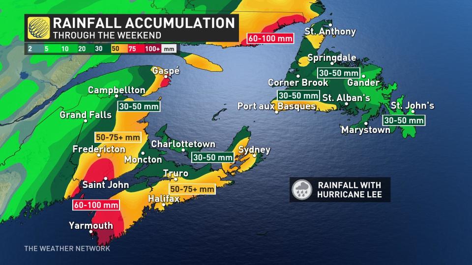 Between 60-100 mm of rain is possible in the southern Maritimes over the weekend. The risk for flooding has increased over western Nova Scotia and the Annapolis Valley.
“There could be heavy amounts in the vicinity of the track itself with indications of possibly 75 mm directly from Lee,” the CHC warns. “This combined with the rain that fell there Thursday increases the vulnerability to further flooding in that area.”
WATCH: Hurricane Lee prep is underway for Maritimes residents
WIND
At the same time, winds will pick up late Friday and peak on Saturday, with gusts of 70-100 km/h expected.
Communities along the coast can expect the storm’s strongest winds, with wind speeds quickly decreasing inland. Areas under the hurricane watch will likely see the strongest winds, with gusts as high as 120 km/h possible at times. These winds would typically result in some tree damage and power outages. Gusty winds are still possible Sunday even as conditions improve.
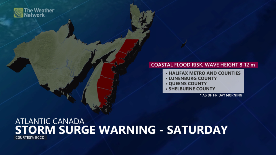
STORM SURGE
High waves and elevated water levels will be widespread due to the large size of the storm. Rough waves and storm surge flooding will pose the greatest threat to coastal communities on the Bay of Fundy shores and the southwest coast of Nova Scotia.
A storm surge warning has been issued for Halifax Metro and Halifax County West, Halifax County – East of Porters Lake, Lunenburg County, Queens County, Shelburne County, Guysborough County. People near the coast are being urged to monitor for worsening conditions and be prepared to move to a safer location at a moment’s notice.
“For Atlantic coastal Nova Scotia, breaking waves of 4-6 metres (15 to 20 feet) are likely,” says the CHC. “Elevated water levels (storm surge) combined with waves could result in coastal flooding during the high tide late morning to noon Saturday in Shelburne County then during the high tide late Saturday evening along the coast from Queens County to eastern Halifax County.”
Folks across the region are understandably weary about tropical systems after the impacts of Dorian in 2019 and Fiona in 2022.
It’s likely that Hurricane Lee will not be as strong as either of those two systems. However, residents do need to stay on high alert for flooding, power outages, tree damage and coastal flooding.
Stay prepared
We’re now in the climatological peak of hurricane season across the Atlantic basin. Anyone along or near the East Coast should prepare for hazards like power outages and flooding regardless of this one storm’s progress.
Ensure you’ve got non-perishable food, water, personal hygiene supplies, flashlights, and batteries to last for several days without electricity or water. Prepare an emergency plan in case of flooding or evacuations.
As we continue to monitor #HurricaneLee’s path, Nova Scotians have time to prepare an emergency kit before bad weather arrives. pic.twitter.com/n5FdPfdXki
As we continue to monitor Nova Scotia EMO on Twitter: “As we continue to monitor #HurricaneLee’s path, Nova Scotians have time to prepare an emergency kit before bad weather arrives. pic.twitter.com/n5FdPfdXki / Twitter”‘s path, Nova Scotians have time to prepare an emergency kit before bad weather arrives. Nova Scotia EMO on Twitter: “As we continue to monitor #HurricaneLee’s path, Nova Scotians have time to prepare an emergency kit before bad weather arrives. pic.twitter.com/n5FdPfdXki / Twitter”
— Nova Scotia EMO (@nsemo) Nova Scotia EMO on Twitter: “As we continue to monitor #HurricaneLee’s path, Nova Scotians have time to prepare an emergency kit before bad weather arrives. pic.twitter.com/n5FdPfdXki / Twitter”
STAY SAFE: What you need in your hurricane preparedness kit
Anxiety is normal when there’s a big storm out there, and even more so when the storm’s future is uncertain. Preparing for a storm long before one arrives ensures you’ll be ready to go if anything looms on the horizon in the weeks and months ahead.
Stay with The Weather Network for the duration of this storm as we closely monitor this hurricane and its developments.
WATCH: Why having a ham radio during hurricanes and storms could be crucial
*****
Credit belongs to : ca.news.yahoo.com