Are you ready for the chill, Alberta? Much of the province has recently enjoyed short-sleeve weather in a month that’s more accustomed to sweaters as persistent ridging allowed above-seasonal temperatures to reign.
The warmer weather has been on borrowed time this week, but now chilly air from the Far North will begin to slip down the Rockies and wash over the western Prairies. We’re looking at the prospect of more than four solid days below freezing in Calgary, complete with a chance for snow in many areas.
SNEAK PEAK: What El Niño means for Canada’s upcoming winter season
October warmth will end in a hurry
It’s been an exceptionally warm month in Calgary so far, where we’ve seen nine days with high temperatures of 20°C or warmer over the past three weeks.
Calgary International Airport maxed-out at 25.8°C on Oct. 8 — a high temperature more common of mid-July than mid-October.
This unusual weeks-long vacation from fall’s typical chill will come to a swift end this weekend as a major pattern change sweeps onto the Prairies.
GET READY: Make these simple routine changes to prevent dry, brittle hair in winter
The upper-level pattern that’s kept us warmer-than-normal will finally start to progress eastward, allowing a sharp trough to dig in and take its place. This will open the atmospheric floodgates and allow brisk air from Northern Canada to spill south and send temperatures crashing down from their lofty heights.
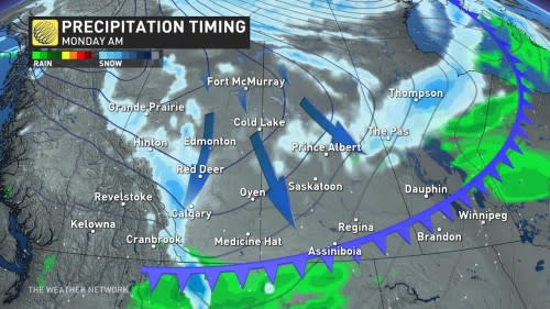
An Arctic front following the Rockies late Sunday into Monday will flip temperatures from above-seasonal to below-seasonal in just a couple of hours.
While the cold air is forced up the Foothills, folks around the region can expect to see some snow falling for the first time this season. An abundance of atmospheric moisture will bump up the snowfall rates and spread the snow toward Calgary and the rest of southern Alberta.
 DON’T MISS: Largest solar storm ever revealed by ancient tree rings
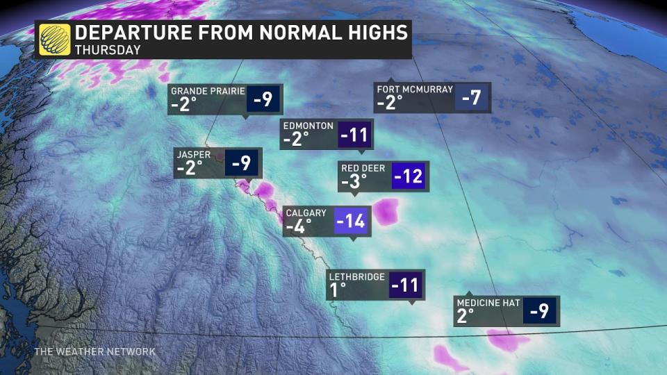
Behind the front, conditions across Alberta will struggle to climb above freezing until the end of the week. Current forecasts for both Calgary and Edmonton push temperatures below 0°C on Sunday night, keeping subfreezing temperatures around until the following weekend.
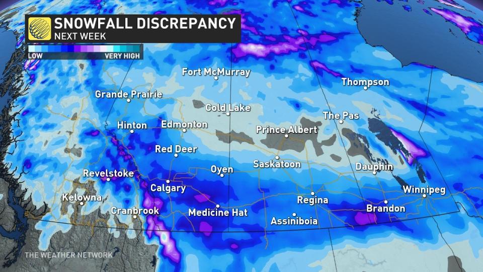
The big event could take place later next week ahead of the weekend warmup when Pacific moisture makes its way over the Rockies on Thursday.
Since this is so far out, however, there is uncertainty about whether the storm will form over Alberta or Colorado, resulting in models putting a snowfall range of 10-30cm for Calgary.
Keep checking back to The Weather Network for more forecast information and updates on your weather across Alberta.
WATCH: Stay heart-healthy while shovelling snow this season
*****
Credit belongs to : ca.news.yahoo.com


