Click here to view the video
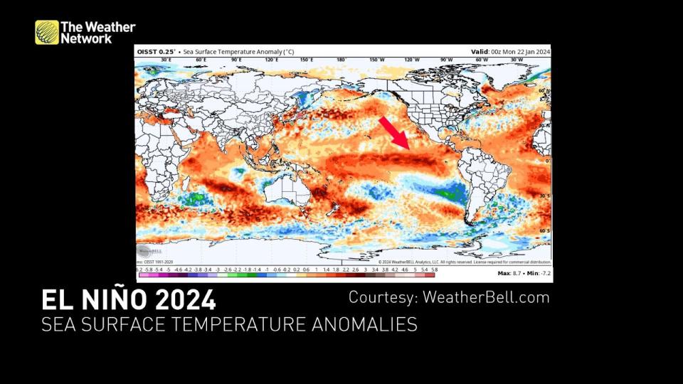
A strong El Niño raging in the eastern Pacific Ocean has had a profound effect on weather patterns the world over—and it may be on borrowed time.
Forecasters see a dramatic change on the horizon.
This pattern of warmer-than-normal waters in the eastern Pacific Ocean may rapidly flip toward ‘neutral’—around average—and even tilt toward the cooler-than-normal waters of La Niña just in time for this summer’s hurricane season.
DON’T MISS: El Niño to break Canada out of a record-cold January
Local changes lead to global effects
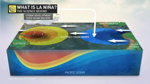
El Niño and La Niña are patterns of warmer- and cooler-than-normal sea surface temperatures in the eastern Pacific Ocean off the western coast of South America.
Under normal conditions, easterly winds push warm surface waters from South America toward Australia. This forces cold water from deep within the ocean to rise toward the surface off the South American coast.
 During an El Niño, those prevailing winds weaken or even reverse direction, allowing all that warm surface water to rush back toward South America and heat up the eastern Pacific Ocean.
But if those easterly winds strengthen instead of weaken, the push of warm water toward Australia accelerates and forces a tremendous amount of deep, cold water to rise to the surface off South America’s coast to create a La Niña event.
They’re seemingly small changes that have big impacts around the world.
Canada’s felt El Niño’s influence in a big way this winter
You don’t have to be a meteorologist to understand the impacts of an El Niño pattern across Canada—you’ve been living it!
Canada has experienced a winter of extremes this season, and most of those extremes fell on the positive side of the freezing mark.
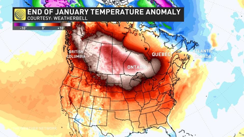
Our pattern flipped in a hurry after the holidays. A bitter and historic chill poured across Western Canada and allowed folks to enjoy some winter activities while they could.
The frigid pattern didn’t last, though, and our pattern flipped again to feature the more typical El Niño flavours of warm and mild through the last week of January.
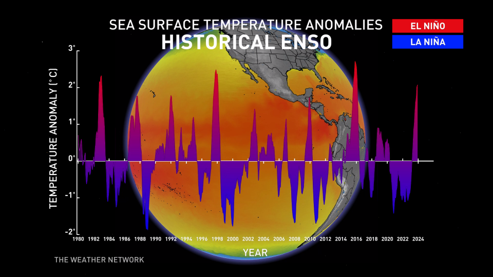
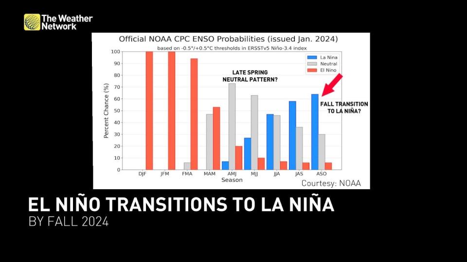
El Niño will likely wane by spring—with La Niña not far behind
It’s rare for even a strong El Niño to last longer than a year, so it’s no surprise that we’re not far from this pattern finally giving way.
Researchers have found that strong El Niño events typically see a La Niña build in soon after, which is exactly what the latest forecasts reflect as we head through 2024.
Our strong El Niño is on borrowed time. We’re likely going to see the warmer-than-normal waters of El Niño linger into the spring months even as temperatures begin to moderate a bit.
Forecasters see decent odds that water temperatures in the eastern Pacific will return to around seasonal by the latter half of spring, putting us in ‘neutral’ territory that doesn’t have much of an effect on global weather patterns.
The greatest impact La Niña has on North American weather patterns in the warmer months is minimizing destructive wind shear that blows over the Atlantic Ocean, which makes conditions more favourable for tropical storms and hurricanes to develop.
Wondering what El Niño may have in store for the rest of Canada’s winter and the upcoming spring?
Stay tuned for Dr. Doug Gillham’s February outlook coming out next week, and look out for The Weather Network’s exclusive spring forecast on February 28th.
WATCH: December saw record-breaking warmth, do we blame El Niño or climate change?
*****
Credit belongs to : ca.news.yahoo.com