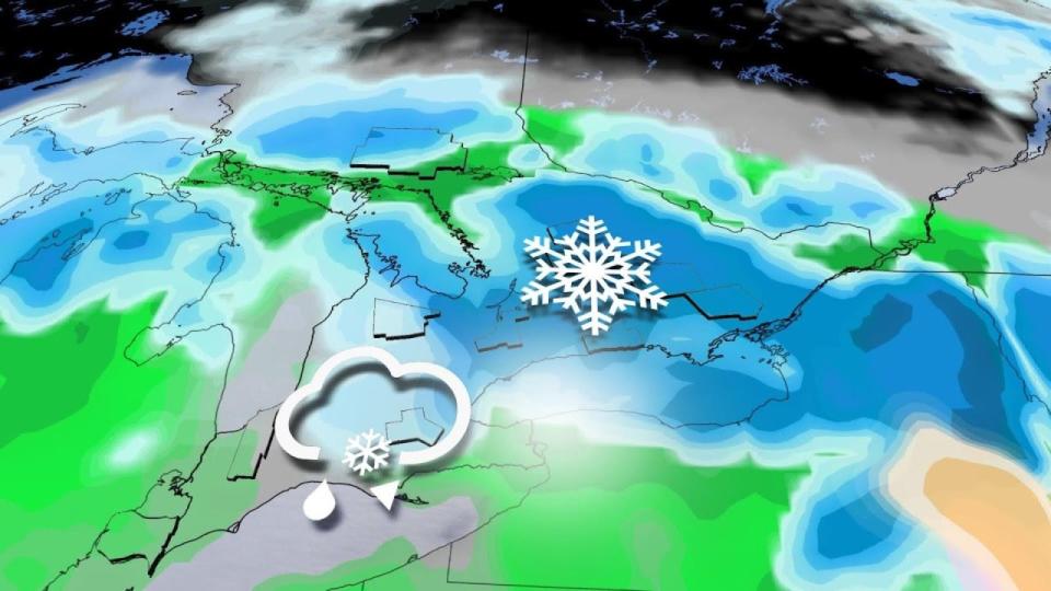
This week’s forecast across Ontario and Quebec is a rude reminder that winter is still in charge across Canada even as we creep deeper into spring.
Anyone who took their winter tires off already may have tempted fate as we face periods of rain and heavy, wet snow across southern Ontario and Quebec starting Tuesday and lasting into Thursday.
DON’T MISS: Canada faces a fickle April as winter wanes and summer teases
 A complex setup will see two distinct low-pressure systems affect the region through the middle of the week. The first system will move into the Great Lakes on Tuesday and Wednesday, with the second storm affecting eastern Ontario and southern Quebec on Wednesday into Thursday.
It’s still a bit too early to pinpoint exactly where the transition between rain and snow will occur. However, forecasters are confident that this will be a disruptive system across the region. Plan ahead for likely travel issues and potential power outages through the middle of the week.
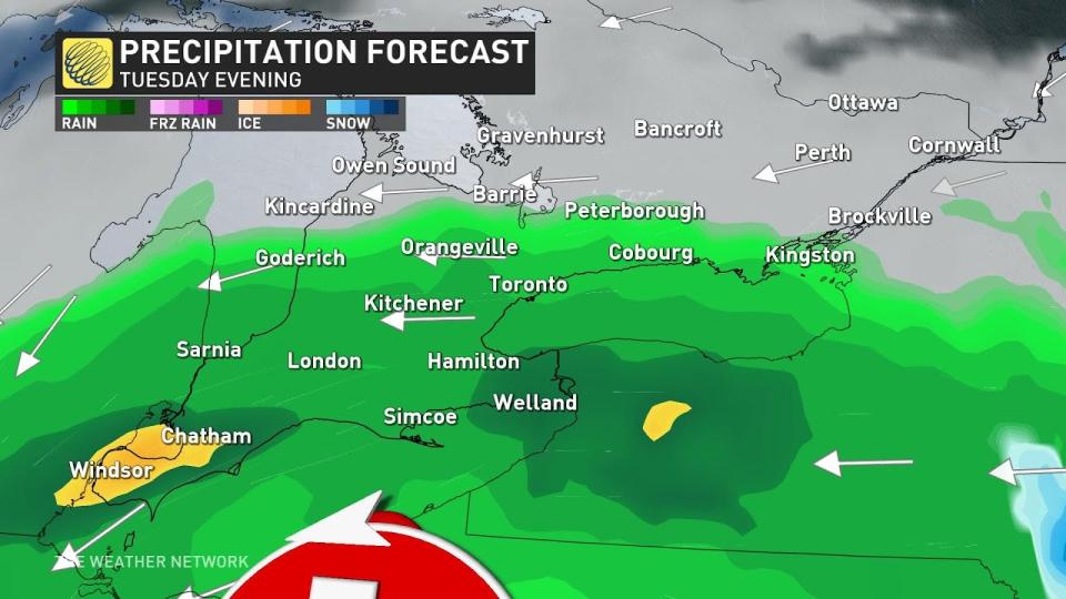
Tuesday into Wednesday morning: Rainfall switches to wet snow, winds ramp up
We’ll see a Colorado low pushing into the lower Great Lakes through the day Tuesday, pushing a slug of widespread rain into southwestern Ontario. The rain will spread across the rest of southern Ontario as the day continues, with periods of heavy rain at times.
ECLIPSE FORECAST: Here’s an early look at how weather may affect eclipse viewing
Temperatures will fall as the storm pulls in colder air from the north. We’ll see rain transition to wet snow across higher terrain late Tuesday afternoon, with the rain/snow line migrating toward Lake Ontario by Wednesday morning.
Gusty winds will accompany the heavy precipitation overnight Tuesday into Wednesday. We’re likely to see a strong east wind blowing off Lake Ontario by Tuesday evening. Sustained winds close to 50 km/h with gusts to 80 km/h will lead to a threat for scattered power outages.
The combination of gusty winds and heavy snow across inland areas will lead to reduced visibility and potential whiteout conditions at times. Travel will be extremely difficult at times Tuesday night.
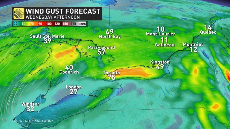
Wednesday: Rain and snow persist, gusty winds may cause power outages
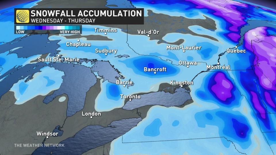
Ontario and Quebec will likely see the greatest impacts from this messy setup on Wednesday as our first storm continues and our second low-pressure system ramps up.
A long-duration bout of heavy, wet snow will continue for inland areas through much of the day Wednesday. Slick roads will persist throughout the Greater Toronto Area into the Wednesday morning commute, with gusty winds further complicating travel at times.
Given that we’re still four days out, forecasters have low confidence in precisely where the transition between rain and snow will occur. Inland areas that see the heaviest and most persistent snow could possibly exceed 20 cm by Wednesday.
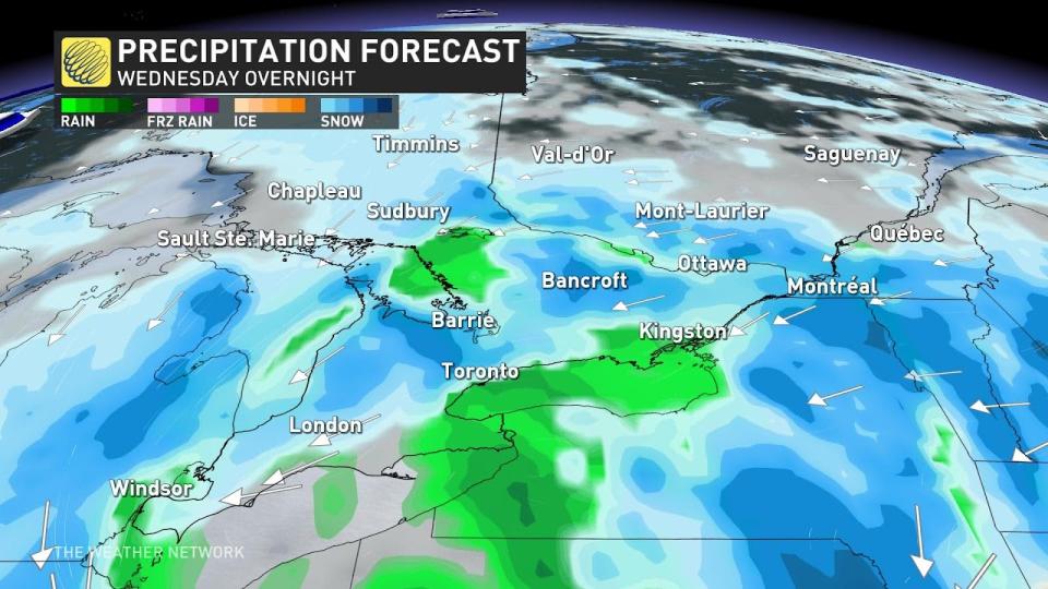
Thursday: Second system brings heavy snow to eastern Ontario, Quebec
Our initial low-pressure system over southern Ontario will weaken through the day Wednesday as a newborn coastal low develops over New England into Thursday.
This newborn system will likely bring a continued threat for heavy snow across eastern Ontario and southern Quebec.
Beyond the system, expect blustery and chilly conditions for a couple days as the system slowly departs the region, then a warming trend into next weekend with temperatures climbing well above seasonal. Forecasters will continue to monitor conditions ahead of the total solar eclipse that’ll traverse the region on Monday, April 8.
Stay with The Weather Network for the latest on conditions across Ontario and Quebec.
WATCH: Early signs point to hope for eclipse watchers in Canada
*****
Credit belongs to : ca.news.yahoo.com