
We’ve made it to the final act of the Prairies’ most impactful winter storm of the season. Heavy snow and gusty winds will continue whipping through portions of Saskatchewan and Manitoba overnight Sunday and into Monday morning before finally tapering off.
Heavy snowfall rates and wind gusts in excess of 40 km/h will lead to whiteout conditions for communities still trudging through heavy snowfall.
Travel will remain extremely difficult or downright impossible for the duration of the storm. Widespread road closures were in effect throughout southern sections of Saskatchewan and Manitoba late Sunday as a result of the deep snows and poor visibility.
MUST SEE: Expect a turbulent March across Canada as the seasons duke it out
Widespread road closures in Sask. and Manitoba
The persistent, wind-whipped snows forced officials to close roads across the region on Sunday due to dangerous driving conditions.
The following roads were closed as of 7:00 p.m. local time on Sunday. Be sure to stay on top of road conditions across the region as this storm continues overnight.
Major Saskatchewan road closures, via Highway Hotline:
- Highway 1 (Trans-Canada Highway) between Balgonie to the Manitoba border
- Highway 8 from Hwy 22 to Hwy 13, including Moosomin
- Highway 10 from Fort Qu’Appelle to Balgonie
- Highway 47 from Jct Hwy 48 to Jct Hwy 1
- Highway 48 from Kegworth to the Manitoba border
- Multiple local highways east of Regina
- Multiple local highways east of the Battlefords
Major Manitoba road closures, via Manitoba 511:
- Highway 1 (Trans-Canada Highway) from Griswold to Austin, including Brandon
- Highway 5 from the Sask. border east through Dauphin
- Highway 10 from Dauphin south to Riding Mountain National Park
- Highway 16 from the Sask. border east to Newdale
- Highway 20A from Winnipegosis south to Dauphin
- Highway 45 from Russell to Highway 10
- Most of Highway 83 from Swan River south to Russell
Blowing snow continues overnight
A low-pressure system trekking across the Prairies reached its peak strength on Sunday as the storm spun over the eastern half of the Prairies.
Bands of snow near the heart of the storm grew so intense Sunday afternoon that numerous lightning strikes occurred over southwestern Manitoba between Brandon and Portage la Prairie.
Hail reported in Somerset, MB. Approximate time 2:25pm CST. Permission to post photo and video. #mbstorm #mbwx pic.twitter.com/gdu7CfGjA6
Hail reported in Somerset, MB. Approximate time 2:25pm CST. Permission to post photo and video. Suzanne Pothe on Twitter: “Hail reported in Somerset, MB. Approximate time 2:25pm CST. Permission to post photo and video. #mbstorm #mbwx pic.twitter.com/gdu7CfGjA6 / Twitter”Suzanne Pothe on Twitter: “Hail reported in Somerset, MB. Approximate time 2:25pm CST. Permission to post photo and video. #mbstorm #mbwx pic.twitter.com/gdu7CfGjA6 / Twitter”Suzanne Pothe on Twitter: “Hail reported in Somerset, MB. Approximate time 2:25pm CST. Permission to post photo and video. #mbstorm #mbwx pic.twitter.com/gdu7CfGjA6 / Twitter” — Suzanne Pothe (@Spothe) Suzanne Pothe on Twitter: “Hail reported in Somerset, MB. Approximate time 2:25pm CST. Permission to post photo and video. #mbstorm #mbwx pic.twitter.com/gdu7CfGjA6 / Twitter”
A full-blown thunderstorm even produced a period of hail near Somerset, Manitoba—no small feat when temperatures are hovering around the freezing mark.
Warmer temperatures around Winnipeg led to a period of freezing rain on Sunday. This ice should transition over to snow as colder temperatures wrap into the area to end the storm.
 Heavy snow and gusty winds will continue pummeling southern Saskatchewan and southern Manitoba through the overnight hours Sunday and into Monday morning. Snowfall rates of 2-4+ cm per hour are likely in the strongest bands of snow heading into the evening hours.
Gusty winds of 50-70 km/h will lead to blowing snow and near-zero visibility overnight. The dry and powdery nature of freshly fallen snow will make reduced visibility a hazard even after precipitation ends.
LEARN MORE: How the tropics help produce big springtime snows on the Prairies
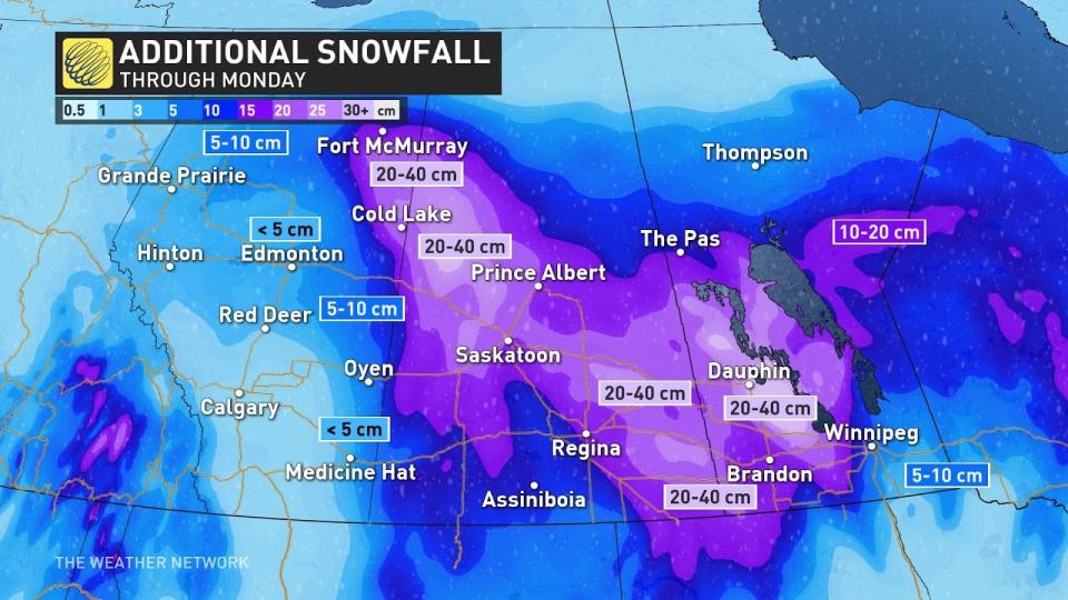
Expect a widespread swath of 20-40 cm of snow from central Saskatchewan to the Manitoba Lakes, including Prince Albert, Saskatoon, Regina, and Dauphin.
If you’re already tired of the snow, fear not. While frigid temperatures will remain locked across the Prairies through the middle of the week, a warm-up is on the horizon heading into next weekend and beyond.
Stay with The Weather Network for all the latest on this snowstorm across the Prairies.
WATCH: Pileup on Trans-Canada Highway caused by zero-visibility snowstorm
*****
Credit belongs to : ca.news.yahoo.com