
It’s a tough reality check this time of year. April carries spring on its breezes, after all. Flower petals float through the sky as a blanket of pollen turns everything a sneezy shade of yellow.
But winter is determined to hang on even if the season was absent in its prime across much of the country. Here’s a look at what forecasters expect to unfold next week as a chilly pattern takes hold.
DON’T MISS: How the tropics help produce big springtime snows on the Prairies
![]() We’re starting the weekend on a spring-like note across the country as unseasonable warmth builds on the Prairies while a rainy system takes its time churning into the East Coast.
We’re starting the weekend on a spring-like note across the country as unseasonable warmth builds on the Prairies while a rainy system takes its time churning into the East Coast.
Comfortable temperatures expected from Calgary to Winnipeg this weekend won’t last much longer as a pattern flip descends on Western Canada to start the next week.
An upper-level trough sliding down the West Coast will kick off a period of active weather that’ll lumber east across the country throughout next week.
Metro Vancouver will stay far too warm to see any flakes, but below-seasonal temperatures will allow for snow at higher elevations along the South Coast and B.C.’s Interior. This is great news for ski resorts hoping to extend the season a bit.
MUST SEE: B.C.’s spring snowpack is the lowest on record, increased wildfire risk
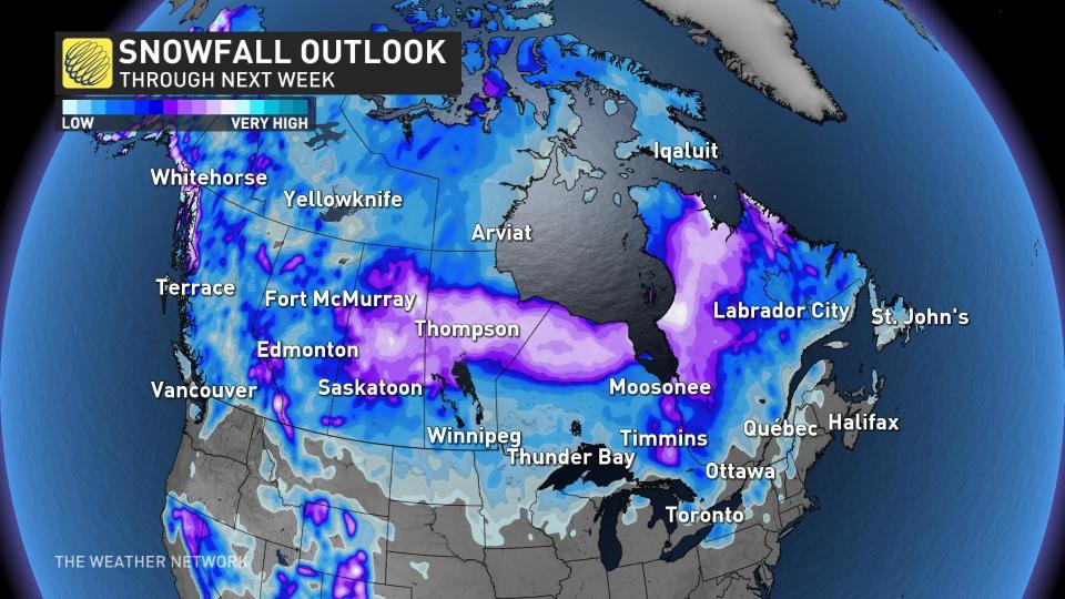
South of the border, a sprawling Colorado Low will push toward the eastern Prairies and the Great Lakes. This system will overtake that Prairies low and become our dominant weather-maker heading into the latter half of the week.
Foul conditions are likely across the eastern Prairies and Ontario through the middle and end of next week, with a likely transition to snow behind the system. There’s even a potential for wet snow to creep into parts of southern Ontario north of the Greater Toronto Area.
This storm will then roll toward Quebec and Atlantic Canada, bringing more opportunities for steady rain, gusty winds, and additional snow for northern and inland areas.
All told, we’re looking at the potential for snow to fall on every province and territory next week, with the possible exception of Nova Scotia and Prince Edward Island.
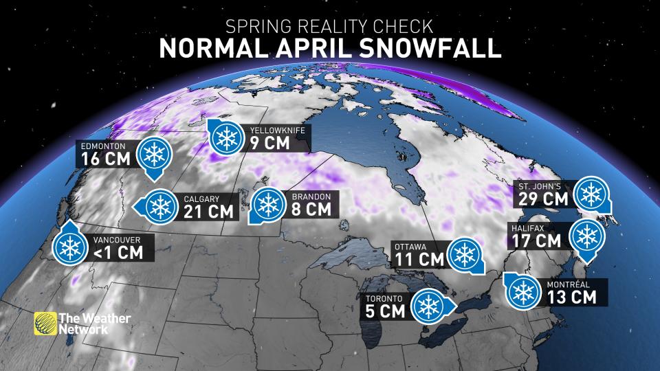
Snow in April is fairly common across the country. Almost every major city save for Vancouver picks up some accumulating snow in a typical April—even Toronto. Calgary averages about 21 cm of snow in April, while Halifax typically measures about 17 cm during a normal month.
Don’t put those coats and snow brushes away too soon. Comfortable air and feisty thunderstorms are making their moves, but winter isn’t done with us just yet.
WATCH: Encore snow forecast for the ski resorts on closing weekend
Header image courtesy of Unsplash.
*****
Credit belongs to : ca.news.yahoo.com