 Well, Ontario, we hoped you enjoyed the extended summer over the last several days since fall has now returned to the province in a hurry.
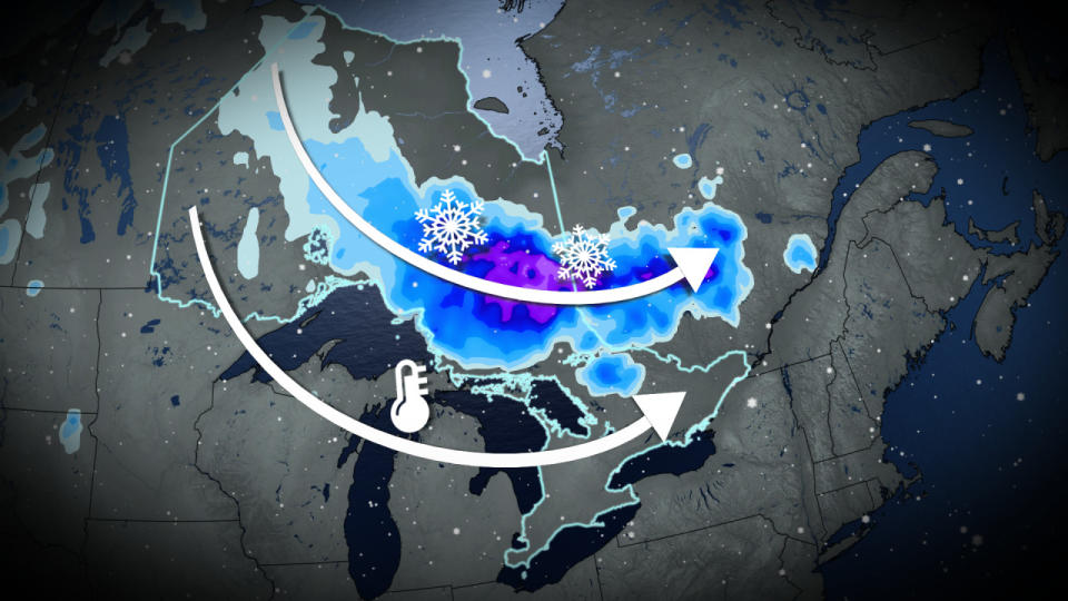
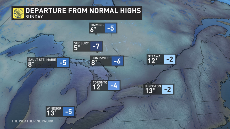
A sliver of the polar vortex trapped in a deep trough will not only drive temperatures down, but also snowfall potential for some and rain for others. Temperatures will be 5-10 degrees below normal for the province this long weekend.
DON’T MISS: Polar vortex to replace Canadian heat with chill, snow
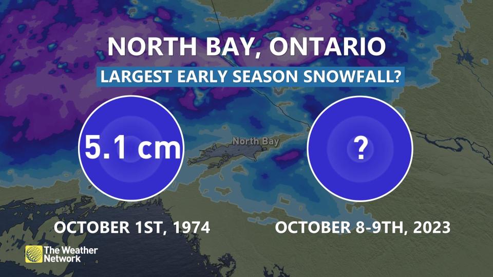
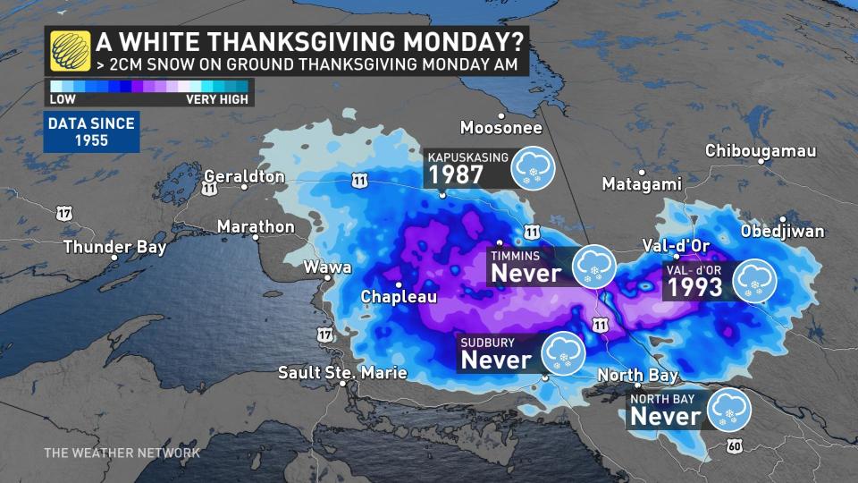
If North Bay, Ont., accumulates more than 5 cm of snowfall, it will be the heaviest, early-season snowfall on record for the region. That’s data going back to 1939.
Autumnal weather arrives, along with snow for some
Areas: Southern and northeastern Ontario
Timing: Through the long weekend
Weather: Wet snow and localized accumulation is forecast for Thanksgiving for parts of Ontario as we plunge from feeling like July to feeling like November in a matter of days. There’s even an outside chance this will become one of the heaviest, early-season snowfalls on record across northeastern Ontario.
By Sunday into Monday, temperatures will struggle to reach the double digits nearly provincewide, with Toronto’s daytime high expected to be 10°C on Thanksgiving Monday. But farther north, it’s worse.
 As Sunday progresses, a cool northwesterly flow will transition rain to wet snow across a large portion of northeastern Ontario. Some residences will awaken to accumulation on Thanksgiving Monday, and there’s a chance it’s record-breaking for North Bay.
Visit our Complete Guide to Fall 2023 for an in-depth look at the Fall Forecast, tips to plan for it and much more!
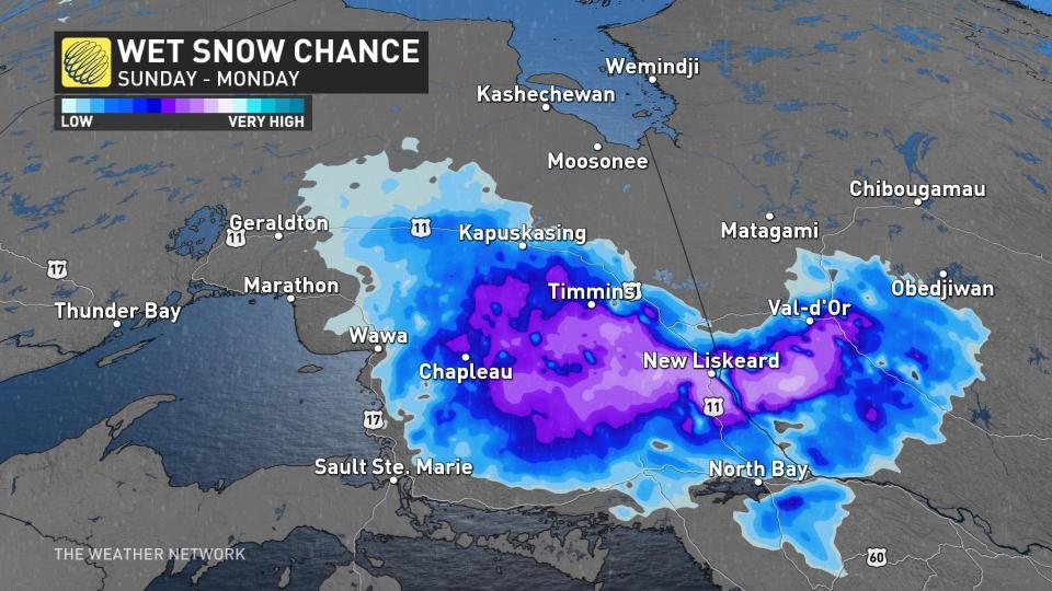
Under heavier precipitation, temperatures will be hovering just above the freezing mark Sunday night, converting lingering rainfall into a wintry-mix from Sudbury to Kapuskasing. Precipitation may oscillate between rainfall and snow, depending on intensity. Highways 11 and 144 will see the highest snowfall amounts, locally over 10 cm possible north of the Trans-Canada Highway.
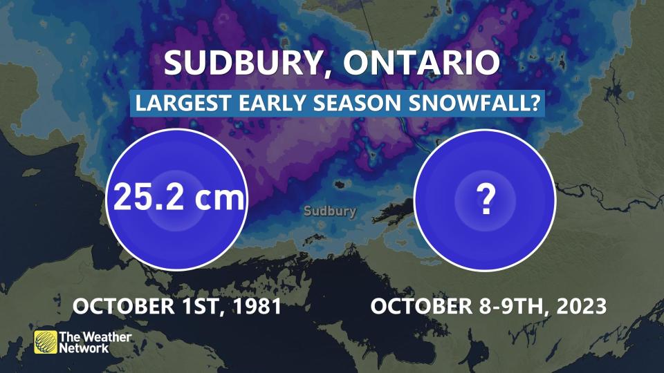 It’s highly unlikely Sudbury, Ont., will have its greatest, early-season snowfall on record as Oct. 1, 1981 has something to say about that.
More 25 cm of snowfall was recorded to kick off October. That day failed to warm much above 1°C, with heavy snowfall developing around the noon hour.
But, a white Thanksgiving? That might just be a first on Monday morning for Timmins, Sudbury, and North Bay. Since 1955, there has been no record of this occurring before. It’s been snow-free since 1987 for Kapuskasing.
 This colder, Arctic air mass over the warmer waters of the Great Lakes sets up a temperature contrast, which drives interesting weather in the region. First is the lake-effect precipitation, with the shores of Lake Huron and Georgian Bay likely to see persistent rain showers on Saturday and Sunday.
The second is funnel cloud and waterspout sightings over the lakes. This weekend may offer ample chances. Northwesterly winds will also settle in a chill provincewide as this system stalls over the northeast, moving backwards rather than a typical eastward track.
Temperatures will trend closer to seasonal values in the mid-teens for mid-and late next week, but with the potential for another system late next week or weekend.
Find out what the rest of October has to offer in our October outlook.
Thumbnail image courtesy: Getty Images.
*****
Credit belongs to : ca.news.yahoo.com