A fresh round of lake-effect snow squalls will likely cause more problems for motorists in parts of southern Ontario on Wednesday.
Brace for potential delays on the roads throughout the day, and with gusty winds expected, stay on guard for rapidly changing conditions if you have to drive through the impacted areas.
Visit our Complete Guide to Winter for an in-depth look at the Winter Forecast, tips to plan for it and much more!
In fact, Environment and Climate Change Canada (ECCC) is advising those in the areas under watches and warnings to consider postponing non-essential travel.
Some areas near Georgian Bay and Lake Huron may see 5-15 cm by the time the snow ends.
Snow squalls bring difficult travel Wednesday as temperatures drop and winds increase
Chillier air settles in on Wednesday behind a cold front. Most temperatures will be seasonal or slightly below. Colder air and winds from the northwest will drive lake-effect snow across southern Ontario.
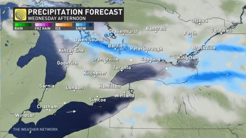
Wind gusts may reach 40 km/h, potentially exceeding 50 km/h at times. When paired with falling snow, that could cause periods of reduced visibility or whiteout conditions. That may impact commutes using Highway 400 by Wednesday afternoon.
The squalls may be strong enough for flakes to fly east of the Greater Toronto Area (GTA), though little will accumulate.
DON’T MISS: Is it safe? How thick does ice need to be to walk or skate on?
Highest snowfall amounts will be off the Lake huron and Georgian Bay shores, with 5-15 cm forecast and locally higher amounts. Barrie may see closer to 5-10 cm.
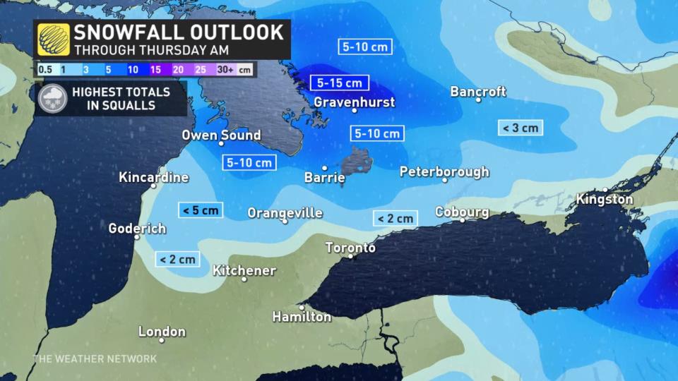
Totals drastically fall farther away from the lake-effect snow bands.
Thursday morning will see conditions improve, ahead of a very mild and sunny Friday forecast. The weekend appears quite pleasant, with temperatures 5-10 degrees above seasonal, accompanied by a mix of sun and cloud.
Going somewhere? Check out the current highway conditions before heading out!
Mild temperatures are expected into early next week, but a quick shot of colder weather for Tuesday, with near-seasonal values for southern Ontario and a few degrees colder than seasonal for eastern areas –– lingering into Wednesday.
Stay with The Weather Network for all the latest on conditions across Ontario.
WATCH: Snow in the forecast? Be ready for winter driving with these tips
*****
Credit belongs to : ca.news.yahoo.com