 Southern Ontario will be stuck in an active storm track, accompanied by some less-than-stellar summer temperatures, as multiple rounds of heavy rain and storm threats are forecast all week.
SEE ALSO: Toronto, Ottawa, unlikely to hit 30°C at all this August
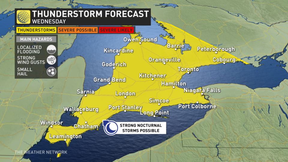
Wednesday will be watched by forecasters closely as the threat for thunderstorms includes heavy downpours, which could lead to localized flooding in some areas due to their sluggish speed.

Wednesday
Areas: Southern Ontario
Timing: Wednesday
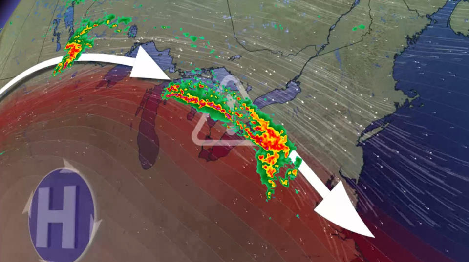
Weather: While a warm and dry high-pressure pattern develops stateside, Ontario’s weather this week will be anything but that. The boundary of the high will drive rounds of worrisome rainfall into southern Ontario through Wednesday and beyond.
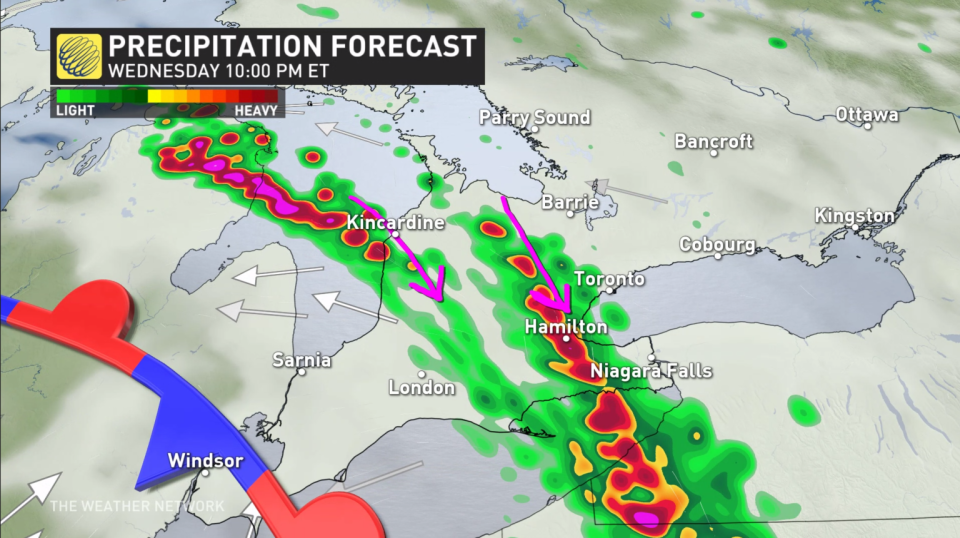
The first round begins Wednesday morning, drying up but remaining overcast into the afternoon. Flooding concerns rise during round 2, which will impact the evening commute home.
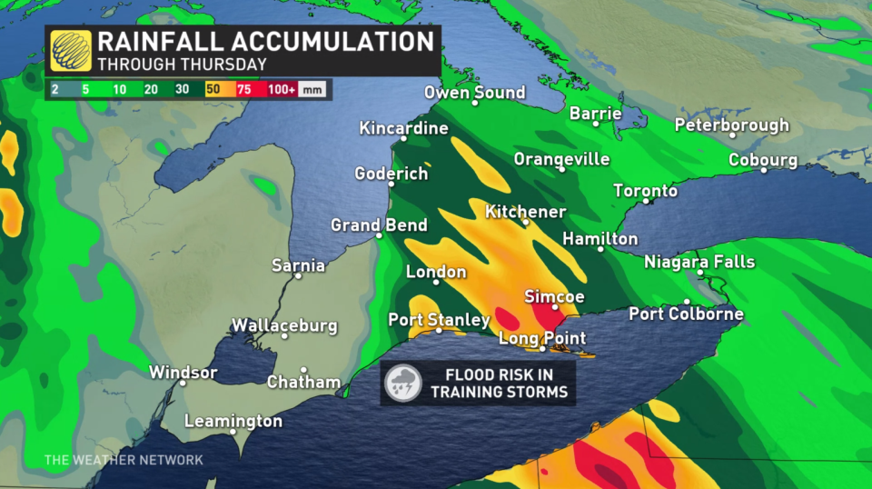
 The slow and narrow track of these early-evening storms is a setup known as training thunderstorms. That means one rainy storm is followed by another, and then another.
In a short period of time, rainfall totals may exceed 50 mm where the storms linger over the same region, risking localized flooding, pooling and ponding on the roadways. That will be possible between the west end of the Greater Toronto Area (GTA) to London. The round of storms will also spill into the overnight hours, leading to round 3: Nocturnal storms in the southwest.
 Enough thunderstorm energy for larger hail and severe thunderstorms may build into Windsor, Chatham and Sarnia by Wednesday evening and overnight. Backing winds mean rotating thunderstorms could be possible. However, the late timing of this environment lowers confidence greatly because of the limited daylight and diminishing dynamics.
Adding to the complexity, that region may lack a storm trigger with the larger boundary located farther north. Forecasters will monitor if a lake breeze or supercell can develop late Wednesday evening. If not, muggy and cloudy conditions are likely from Windsor to London until the boundary dips south very early Thursday morning.
End of the work week
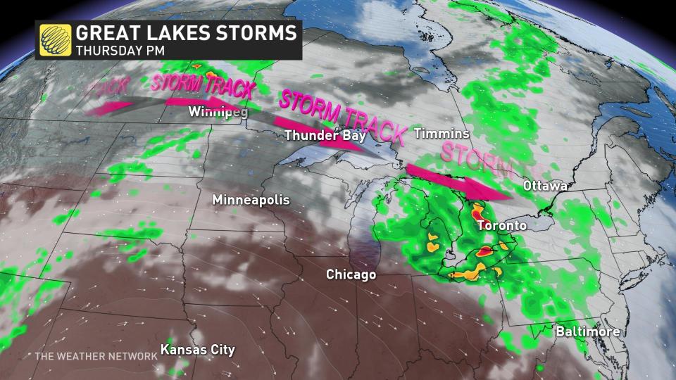
Areas: Southern Ontario
Timing: Thursday and Saturday
Weather: Wednesday we fought the front, but Thursday the low-pressure system itself is up next. Thursday will be fairly similar to Wednesday with multiple rounds of rainfall, heavy at times, intermittently tracking through.
A dry period on Friday will be short-lived as yet another low sets its eyes on Ontario. Saturday will be one to watch with remnants of Hilary risking high rainfall totals once again, likely interrupting weekend plans.
Prepare
Make sure to keep up-to-date on your local forecast information and alerts. If you are outdoors in an area with a severe weather threat, make sure you have a safety plan in place in case you need to get to shelter.
If a severe thunderstorm approaches your location, remain mindful of trees or tree limbs that loom near your home. Trees falling into buildings are a significant source of injury during strong storms. Try to avoid rooms where trees may cause damage during high winds.
The greatest danger in any thunderstorm is lightning. If you can hear thunder, you’re close enough to be struck by lightning.
DON’T MISS: Watch? Warning? How we communicate severe weather in Canada
Be sure to check back for the latest weather updates across Ontario.
*****
Credit belongs to : ca.news.yahoo.com