Idalia took just over 24 hours to go from a Category 1 hurricane to a Category 4.

Hurricane Idalia slammed into the area of Big Bend, Fla., early Wednesday morning as a Category 3 storm, bringing high winds, extreme storm surge and tornadoes to cities along the northern coast of the Gulf of Mexico.
But what was more surprising is that it took just over 24 hours for it to strengthen from a Category 1 hurricane to a Category 4, before it finally lost some steam as it ran into the Florida Panhandle.
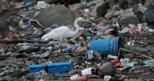
Hurricanes get their fuel mainly from warm ocean waters, and as more greenhouse gases are released into the atmosphere from the burning of fossil fuels, both the Earth’s temperature and the sea surface temperature (SST) rise.
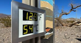
Globally, SSTs have risen to 21 C, the warmest they’ve been on record, and that warming extends to the Gulf of Mexico, where Hurricane Idalia formed.
Recent research has suggested that the warming oceans are causing more intensification — ramping up the strength of hurricanes — as our climate warms.
“If you think of a tropical cyclone in general, it intensifies by extracting energy from the ocean,” said Karthik Balaguru, a scientist for coastal modelling at Pacific Northwest National Laboratory in Seattle.
“So in a broader kind of perspective, if the oceans are warming up more and more as the climate changes, then they will provide a more favourable environment for the storms to intensify.”.
Balaguru said the temperatures in the Gulf of Mexico are 1 C to 2 C warmer than normal.

What is rapid intensification?
“Usually, tropical storms, hurricanes, increase in intensity at a relatively steady rate,” said Gabriel A. Vecchi, professor of geosciences at Princeton University in New Jersey.
“Sometimes they’ll stay at a certain intensity. But every now and again, they’ll undergo the process, which we call rapid intensification. And that is when a hurricane jumps the equivalent of one or so intensity classes in less than 24 hours.”
That’s exactly what happened with Hurricane Idalia.

Vecchi said although rapid intensification has occurred in roughly five per cent of hurricanes, that number is changing.
“The probability of it happening now is considerably more than five per cent,” he said. “And it’s it’s been growing over the last 40 years. We see that increase, not just in the Atlantic Ocean. It’s been sort of relatively throughout the tropics.”
But it’s not all about warmer ocean waters. The atmosphere — specifically wind shear — also plays a vital role in strengthening hurricanes. Wind shear is the change in wind speed as it rises into the atmosphere.
As the winds of a hurricane rush into the storm’s centre, they pick up moisture from the ocean’s surface before spiralling upwards in the eye wall, or the centre of the hurricane. However, if you have high wind shear, dry air moves in, reducing that moisture and helping to destabilize a tropical storm. But if you have low wind shear, that keeps the storm going and can also help to intensify it.
Balaguru recently published a study in Science that suggested wind shear along the Atlantic and Gulf coasts is decreasing, which just adds further fuel to hurricane intensification.
While rapid intensification is of deep concern, especially in coastal cities — as has been seen with Hurricane Idalia, Vecchi said that forecasts are improving, which is saving lives.
“There’s a story of the 1900 hurricane in Galveston, Texas,” he said of the hurricane that killed between 6,000 and 12,000 people. “What you see there is the consequences of a storm in a world where we don’t have predictions, or at least we are not using the predictions that there were. With the storms that we have now, I can imagine it being a lot worse.”
At the time of publication, no deaths from Hurricane Idalia had been reported.
“I hope that everybody is safe, as best as possible,” Vecchi said. “And that as much property is saved as possible. And if that continues to be the story, I can’t imagine that the quality of the forecasts — that communication, the fact that the various media were involved in all of this — didn’t play some role.”

Severe marine heat wave impacting Atlantic hurricane season
CBC News science and climate specialist Darius Mahdavi breaks down how record-warm ocean waters mean Canada could be in a dangerous situation heading into the peak of Atlantic hurricane season should any make landfall here.
ABOUT THE AUTHOR

Senior reporter, science
Based in Toronto, Nicole covers all things science for CBC News. As an amateur astronomer, Nicole can be found looking up at the night sky appreciating the marvels of our universe. She is the editor of the Journal of the Royal Astronomical Society of Canada and the author of several books. In 2021, she won the Kavli Science Journalism Award from the American Association for the Advancement of Science for a Quirks and Quarks audio special on the history and future of Black people in science. You can send her story ideas at Nicole.Mortillaro@cbc.ca.
*****
Credit belongs to : www.cbc.ca