 Visit The Weather Network’s hurricane hub to keep up with the latest on tropical developments in Canada and around the world
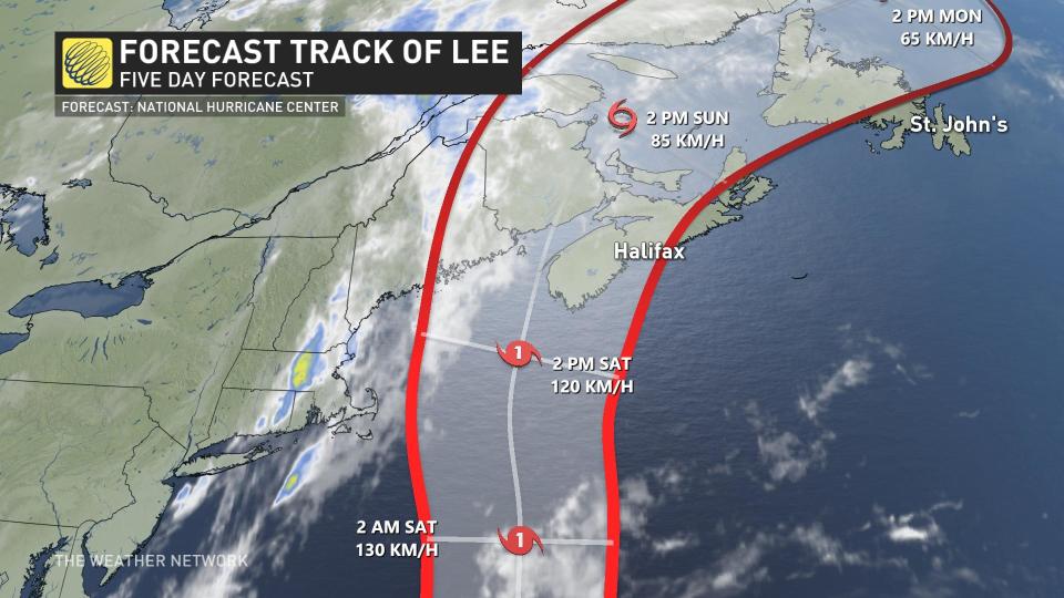
After spending a good amount of time in the open waters of the Atlantic, the weakening Lee, now a Category 2 hurricane, has begun its northerly track along the U.S. East Coast, putting Canada’s Maritime provinces on high alert.
A trough will set up over the eastern United States will help move the storm along at the end of the weekend.
As expected, Lee is expanding in size and has started to weaken as it pushes through cooler waters. Lee is likely to remain a “large and dangerous hurricane into the weekend,” says the U.S. National Hurricane Center (NHC).
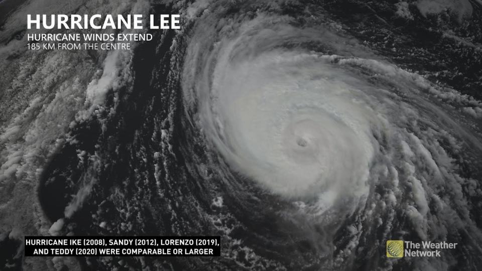
Hurricane-force winds extend outward up to 185 kilometres from the centre, and tropical storm-force winds extend outward up to 425 kilometres.
Lee is likely to remain a ‘large and dangerous’ hurricane into the weekend
The hurricane has already weakened into a Category 2 hurricane, as per the latest NHC update, with sustained winds of 165 km/h, so it will continue to lose strength further as it tracks north towards Atlantic Canada.
DON’T MISS: A world first, every tropical ocean saw a Category 5 storm in 2023
 The fact that Hurricane Lee’s footprint has slowly grown in size despite losing its strength is important for any communities in the eventual path of the storm. A threat for heavy rains, high winds, and coastal flooding could extend hundreds of kilometres from the centre of the storm. The biggest concerns will be high tide, dangerous surf, and coastal flooding.
WATCH: Storm anxiety high among Nova Scotians after a harsh year
Tropical cyclone information statement issued by the Canadian Hurricane Centre
The Canadian Hurricane Centre (CHC) issued a tropical cyclone information statement for the Maritime provinces.
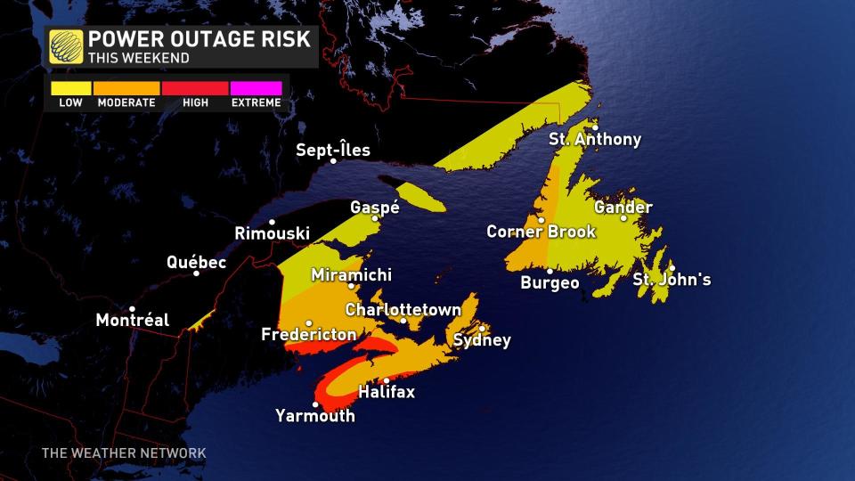
While the exact location of Lee’s landfall is still uncertain, the importance of it decreases as the system becomes larger and the greatest impacts aren’t centred at the core of the storm. The confidence is especially growing for the Maritime provinces and Bay of Fundy region. Residents in these areas, especially closer to the coast, should begin preparing for widespread power outages over the weekend.
 Hurricane Lee has started the trek northward, but as it nears Atlantic Canada, a ridge of high pressure over the ocean is responsible for steering Lee towards the northwest briefly.
The CHC expects Lee’s circulation to broaden significantly as it moves north and anticipates it to move into the Canadian marine district as a Category 1 hurricane. It is looking likely that the forward motion of the storm could slow, and while doing so, winds would start to decrease. The intensity would drop below hurricane strength and it would become post-tropical, the CHC says.
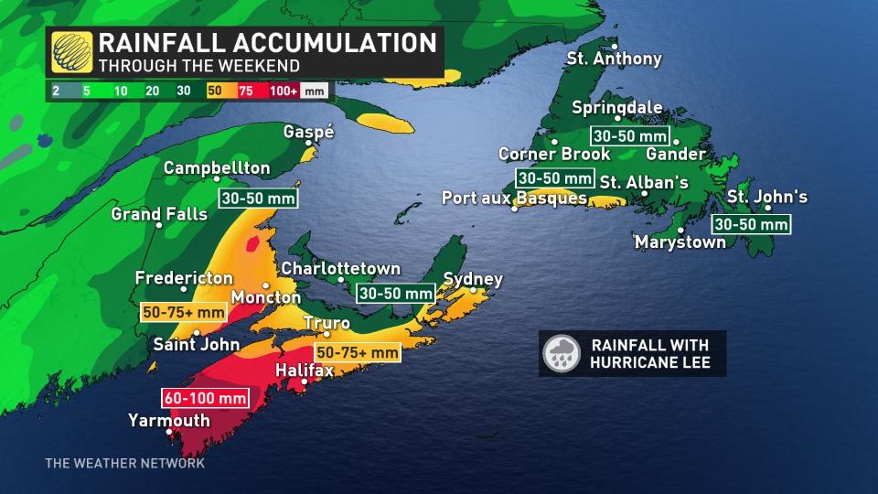
As Lee approaches, rain will start, potentially accumulating to 60-100 mm totals in the southern Maritimes over the weekend. Localized flooding is possible, especially since the ground will be near saturation before the storm begins as tropical moisture fills in.
WATCH: Hurricane Lee’s expanding winds pose a concern for Atlantic Canada
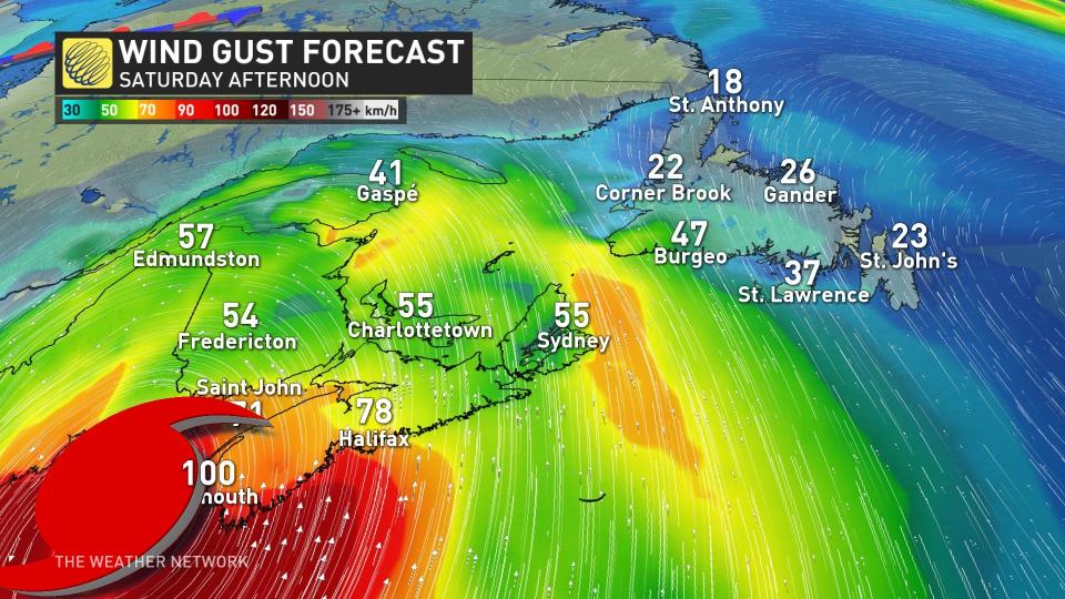
At the same time, wind gusts will pick up late Friday and will peak on Saturday with gusts of 70-100 km/h. Winds will ease for Sunday but will still be gusty. The strongest winds can be expected along coastal sections while quickly decreasing inland.
The greatest threats are the waves and surge immediately along the coast. Waves of upwards to 6-7 metres are possible out to sea. The greatest impacts will be the southwest shores of Nova Scotia and the Bay of Fundy shores.
Folks across the region are understandably weary about tropical systems after the impacts of Dorian in 2019 and Fiona in 2022.
It’s likely that Hurricane Lee would not be as strong as either of those two systems if it was to hit the region. However, residents do need to stay on high alert for flooding, power outages, tree damage and coastal flooding.
Stay prepared
We’re now in the climatological peak of hurricane season across the Atlantic basin. Anyone along or near the East Coast should prepare for hazards like power outages and flooding regardless of this one storm’s progress.
Ensure you’ve got non-perishable food, water, personal hygiene supplies, flashlights, and batteries to last for several days without electricity or water. Prepare an emergency plan in case of flooding or evacuations.
STAY SAFE: What you need in your hurricane preparedness kit
Anxiety is normal when there’s a big storm out there, and even more so when the storm’s future is uncertain. Preparing for a storm now — long before one ever draws near — ensures you’ll be ready to go if anything looms on the horizon in the weeks and months ahead.
Stay with The Weather Network for the duration of this storm as we closely monitor this hurricane and its developments.
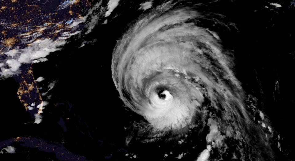
Thumbnail courtesy of NOAA.
WATCH: Why having a ham radio during hurricanes and storms could be crucial
*****
Credit belongs to : ca.news.yahoo.com