 Click here to view the video
The Atlantic Ocean is hopping this Labour Day weekend as forecasters keep tabs on several systems across the basin.
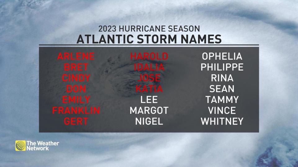
On Friday night, there were six: Two tropical storms, the lurking remnants of Idalia, a new tropical storm, Katia, a looming disturbance near Africa, and the remnants of a once-powerful hurricane are all swirling away as we inch toward the peak of hurricane season.
SEPTEMBER OUTLOOK: Warm or cool? Reversing patterns to dominate Canada in September
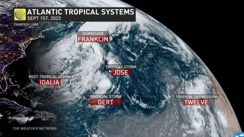
As of Saturday morning, we’re now down to three and there is a potential for a fourth in the near future.
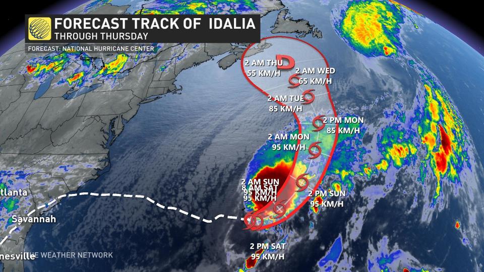
Idalia is down, but not out
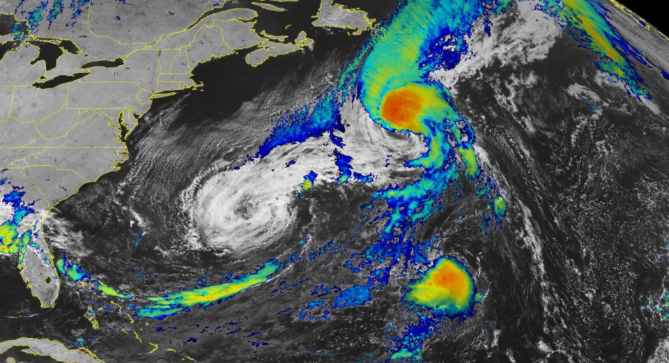
A tropical storm warning will remain in effect for Bermuda for the better part of the weekend as the remnants of Hurricane Idalia make their way toward the small island of about 60,000 people.
Idalia lost its tropical characteristics on Thursday, turning into a post-tropical cyclone that’s more akin to a strong nor’easter. The large system is packing maximum sustained winds of 95 km/h over a large swath of the western Atlantic.
 DON’T MISS: The curse of storm nine: Why so many “I” hurricanes are monsters
Forecasters expect Idalia to regain its tropical characteristics as the low-pressure system interacts with warmer waters near Bermuda, once again growing into Tropical Storm Idalia a full week after it first formed off Mexico’s Yucatan Peninsula.
Gusty winds, high waves, and heavy rain of 75-125 mm are all possible on Bermuda as Idalia sweeps the island through the weekend.
Strong rip currents remain possible along much of the U.S. East Coast as a result of the storm, which will pose a hazard to anyone heading to the beach for the long weekend.
WATCH: Idalia declared region’s strongest hurricane in 125 years
Gert dances through the central Atlantic as Franklin and Jose disappear
Franklin was once a high-end Category 4 hurricane as it passed between the U.S. East Coast and Bermuda earlier this week. The storm was a powerful hurricane at the same time as Idalia, marking the first time in 130 years we’ve witnessed two simultaneous major hurricanes over the Atlantic during the month of August, according to hurricane researcher Dr. Philip Klotzbach.
Much like Idalia before it, Franklin lost its tropical characteristics on Friday as it picked up speed and raced toward the northern Atlantic.
This transition allowed the storm to grow in size while maintaining its hurricane force winds, making ex-Franklin a formidable system as it crosses shipping lanes and transatlantic airline routes. The system should weaken as it approaches the northeastern Atlantic through next week.
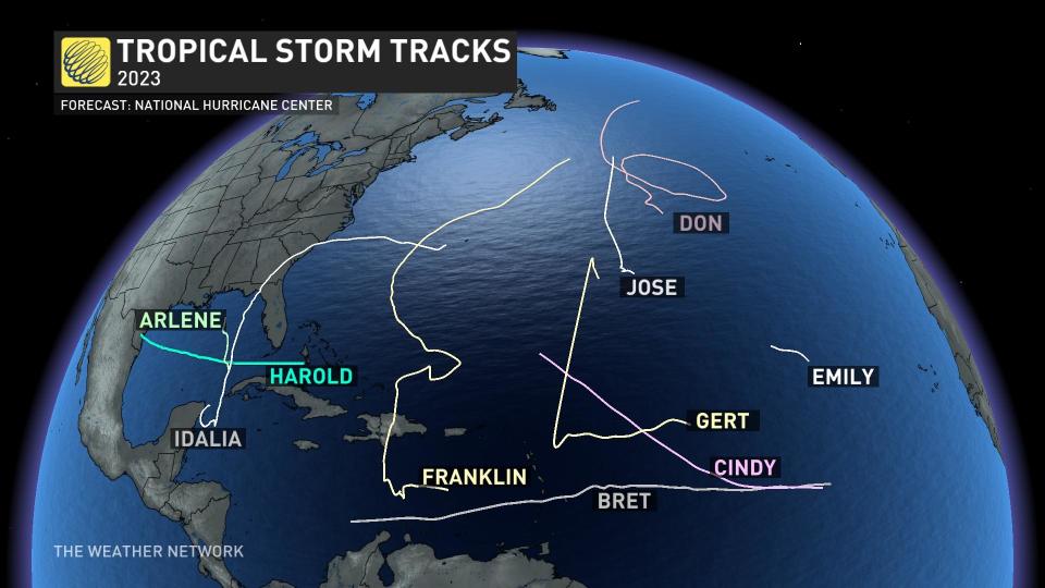 Tropical Storm Jose was a small system that formed in the central Atlantic earlier this week. Jose wasn’t long for the world, either, as it was absorbed by the system formerly known as Franklin on Friday night. They are both no longer tropical entities. It’s common for large systems to absorb smaller, weaker storms in their path.
Gert, meanwhile, is on a revival tour as it spins through the central Atlantic. The weak storm first formed back on August 19 and dissipated three days later. The remnants of Gert continued meandering in the Atlantic for nearly two weeks before regenerating over warm waters again on Friday.
Forecasters expect Gert’s second wind to be as short-lived as its first, likely bidding its final farewell by Sunday as it gets absorbed into nearby Idalia.
A new tropical storm emerges off the west African coast
We have two systems off the western coast of Africa that we’re watching this long weekend.
The first is Katia, which was upgraded to tropical storm on Saturday morning. Katia is not looking to make any major impacts to any land and is projected to dissipate into a depression within sea.
Behind that, though, is a vigorous disturbance making its way into the heart of the tropical Atlantic. This will be the next system worth watching, as it could encounter favourable conditions to slowly develop as it moves west over the next 7-10+ days.
Folks across Eastern Canada will have to keep a close watch on tropical activity in the weeks ahead. No matter how many storms form across the Atlantic, it only takes one storm affecting the area to have a significant impact.
The best time to prepare for a hurricane is before one even has a chance to form. Use these calm days to take stock of your emergency supplies, ensuring you have enough non-perishable food, water, hygiene products, flashlights, and batteries to comfortably make it through several days without electricity or running water.
WATCH: The best time to prepare for a hurricane is before one forms. Here’s how
*****
Credit belongs to : ca.news.yahoo.com