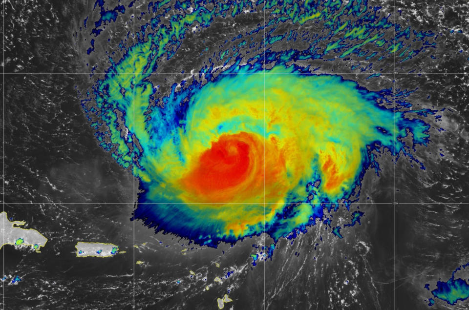
 All eyes are on Hurricane Lee this week as the strong storm traverses the warm waters of the western Atlantic Ocean.
Lee will slow down and begin turning north by the middle of the week, setting up a track that could put Atlantic Canada in line for some hazardous conditions as we head toward next weekend.
Visit The Weather Network’s hurricane hub to keep up with the latest on tropical developments in Canada and around the world
Several scenarios are on the table right now, and the storm’s eventual track depends on the precise timing and location of key factors. Small changes could have a large impact on Lee’s track over the next five to seven days.
Lee regained major hurricane status Sunday
Hurricane Lee held its own through the day Sunday after struggling against a bit of dry air and wind shear on Friday and Saturday.
DON’T MISS: A world first, every tropical ocean saw a Category 5 storm in 2023
Crews flying through the storm saw it beginning to regroup on Sunday, reforming a distinct eye in a bid to regain some of its strength heading into the beginning of the workweek.
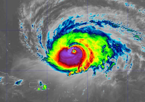
A strengthening Hurricane Lee developed a clear eye on Sunday evening. (NOAA)
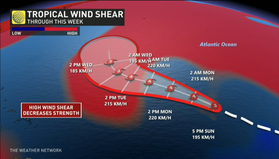
The latest prediction from the U.S. National Hurricane Center (NHC) calls for Lee to strengthen as a major hurricane through Monday and Tuesday before it starts to turn north toward slightly cooler waters.
Lee will weaken a bit as it climbs north and grows in size
It’s important to note that Lee will not remain at its peak strength as it starts turning north by the middle of this week.
Tropical systems tend to grow in size as they curve toward the north, spreading their energy over a wider area rather than focusing all their power on a relatively tiny part of the storm.
The fact that Hurricane Lee’s footprint will slowly grow in size is important for any communities in the eventual path of the storm. A threat for heavy rains, high winds, and coastal flooding could extend hundreds of kilometres from the centre of the hurricane.
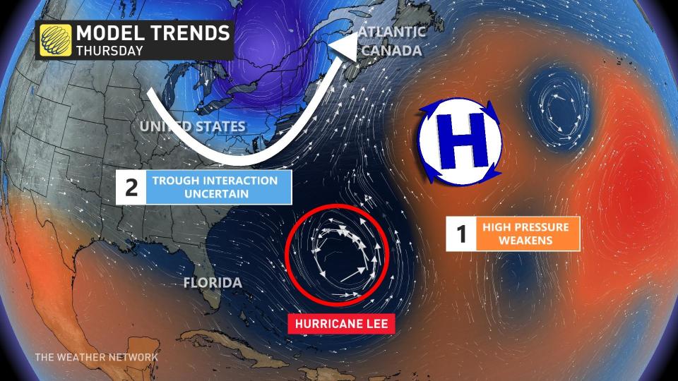
Hurricane Lee’s eventual track will depend on several factors ahead of the storm.
“There still remains a large number of possible scenarios on the table,” the Canadian Hurricane Centre (CHC) said on its Twitter page Sunday afternoon. “So it is still too soon to make any definite statements on what level of impacts, if any, Lee might have in Eastern Canada.”
A ridge of high pressure over the Atlantic is responsible for steering toward the west-northwest right now. This ridge will eventually weaken, causing Lee to slow down and begin turning north by the middle of the week.
 At the same time, Hurricane Lee will start to feel the influence of an upper-level trough dipping over the Great Lakes toward the end of the week. Southerly winds blowing around this trough will help push Lee toward the north with increasing speed on Thursday and through the weekend.
The precise timing of this turn and the strength of that trough will determine exactly where Lee tracks.
Scenario 1: Lee tracks into Atlantic Canada
One scenario consistently showing up in weather models is that prevailing winds will keep Hurricane Lee on a northward trajectory, bringing the storm directly into the Maritimes by next weekend.
This would be a high-impact event for the region, with heavy rain, high winds, and coastal flooding possible across Nova Scotia, New Brunswick, and Prince Edward Island.
Folks across the region are understandably weary about tropical systems after the impacts of Dorian in 2019 and Fiona in 2022. It’s likely that Hurricane Lee would not be as strong as either of those two systems if it were to hit the region.
However, residents would have to stay on high alert for flooding, power outages, tree damage, and coastal flooding.
Scenario 2: Lee turns into New England
Another scenario that’s possible is that the trough over the Great Lakes is a little bit weaker than expected. This would allow a ridge of high pressure to set up near the Maritimes, potentially forcing Lee to turn west and head into New England.
MUST SEE: How a mammoth hurricane rapidly intensifies in mere hours
This scenario would bring hazardous conditions to the bustling Interstate 95 corridor throughout New England—a heavily travelled corridor by Canadians visiting the States—while potentially bringing some wind, rain, and rough surf to southern sections of the Maritimes.
Scenario 3: Lee turns toward sea, possibly affecting Newfoundland
It’s still possible that Lee could turn a bit east and follow a track that heads farther out to sea. This is a similar situation to the one we saw with Hurricane Franklin last month—the storm looked like it might’ve hit Atlantic Canada, but conditions allowed it to turn out to sea. This solution has the lowest probability of verifying compared to the previous two.
If Lee were to turn out to sea, we’d still have to closely monitor potential impacts to Newfoundland, and especially the Avalon Peninsula, by the end of next weekend or early next week.
WATCH: The best time to prepare for a hurricane is long before one threatens. Here’s how
Stay prepared
We’re now in the climatological peak of hurricane season across the Atlantic basin. Anyone along or near the East Coast should prepare for hazards like power outages and flooding regardless of this one storm’s progress.
Ensure you’ve got non-perishable food, water, personal hygiene supplies, flashlights, and batteries to last for several days without electricity or water. Prepare an emergency plan in case of flooding or evacuations.
STAY SAFE: What you need in your hurricane preparedness kit
Anxiety is normal when there’s a big storm out there, and even more so when the storm’s future is uncertain. Preparing for a storm now—long before one ever draws near—ensures you’ll be ready to go if anything looms on the horizon in the weeks and months ahead.
Stay with The Weather Network for the duration of this storm as we closely monitor this hurricane and its developments.
Header satellite image courtesy of NOAA.
WATCH: 2023 has seen a category 5 hurricane in every corner of the tropics
*****
Credit belongs to : ca.news.yahoo.com