The warm waters of El Niño are here to stay through the winter, forecasters say, and the pattern could grow quite strong over the months ahead.
El Niño events typically have a noticeable effect on winter weather across Canada, bringing above-seasonal temperatures to some and a risk for rollicking winter storms to others.
Here’s an early look at how El Niño could influence Canada’s weather this winter based on how previous El Niño winters stacked up across the country.
DON’T MISS: Record-setting summer locks in 2023 as the next hottest year on record
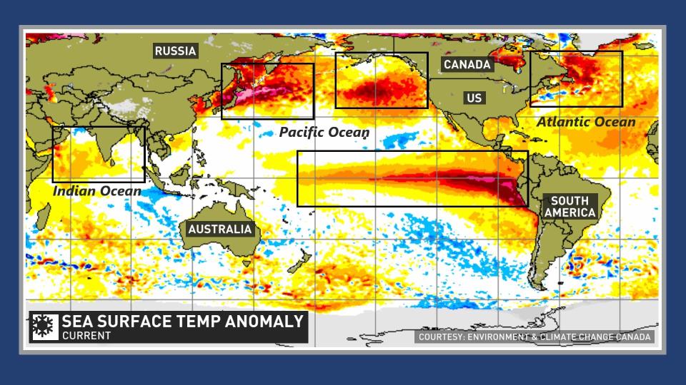
El Niño builds across the Pacific Ocean
Prevailing winds blowing across the Pacific Ocean usually push warmer surface waters west toward Australia and Indonesia. This steady westward flow allows deeper, cooler ocean waters to rise to the surface near South America.
Sometimes, though, this wind pattern breaks down or even reverses direction, allowing that warm water to surge back east toward South America.

When these unusually toasty water temperatures stick around in the eastern Pacific for more than half a year, the anomaly is called an El Niño, and the warmup can have profound effects on weather patterns across North America.
The strength of an El Niño depends on how warm the water temperatures grow. A strong El Niño could have a greater influence on global weather patterns than a weak El Niño.
 Forecasters with the U.S. Climate Prediction Center (CPC) announced on September 14 near-certain odds of El Niño sticking around through the winter, with decent odds of dealing with a strong El Niño through the heart of this upcoming winter.
Warmer waters have a ripple effect around the world
The warmer ocean waters of an El Niño event can warm up the atmosphere above that part of the ocean, which can in turn alter the jet streams throughout the northern hemisphere.
MUST SEE: WHO prepares for El Niño-linked spread of viral disease
Our atmosphere is a deeply interconnected system where nature strives to balance out extremes. A big ridge of high pressure bringing above-seasonal temperatures to one area is usually offset by a trough allowing for colder and more stormy conditions nearby.
We can see it in action during an El Niño winter when a stronger, wavier jet stream rises over North America, building ridges and troughs across Canada that can lead to vastly different conditions between the West and the East.
WATCH: El Niño may lead to more disease outbreaks, here’s why
El Niño winters often see extremes across North America
We often look to the past for clues as to what we can expect in the future. While no two El Niño events are exactly alike, many winters influenced by these warmer ocean waters feature similar patterns.
A typical El Niño winter across North America would see the jet stream jut toward the north, allowing ridges of high pressure to develop over western Canada and the U.S. This type of pattern would bring drier and generally above-seasonal temperatures to the West Coast.
 Just downwind, however, these patterns often see troughs dipping south across the eastern half of Canada, allowing for intrusions of frigid air and an active storm track to develop across the region.
CHECK IT OUT: ‘Feel’ miserable out? Humidex and wind chill are calibrated to your body
The strength of an El Niño also has an effect on these wintertime patterns. Stronger El Niños tend to push the ridge farther to the east, sometimes allowing above-seasonal conditions to push all the way to the Great Lakes, shunting the cold and stormy conditions toward Atlantic Canada.
Folks heading south of the border aren’t immune from El Niño’s effects on winter weather, either.
Popular vacation destinations in the southern United States, especially in Florida, tend to see foul weather during winters influenced by El Niño, including wetter-than-average conditions and more frequent opportunities for severe thunderstorm outbreaks.
It’s important to note that these are general patterns. Patterns that bring above-seasonal temperatures don’t preclude colder conditions, nor would a cooler-than-average pattern prevent occasional warmups.
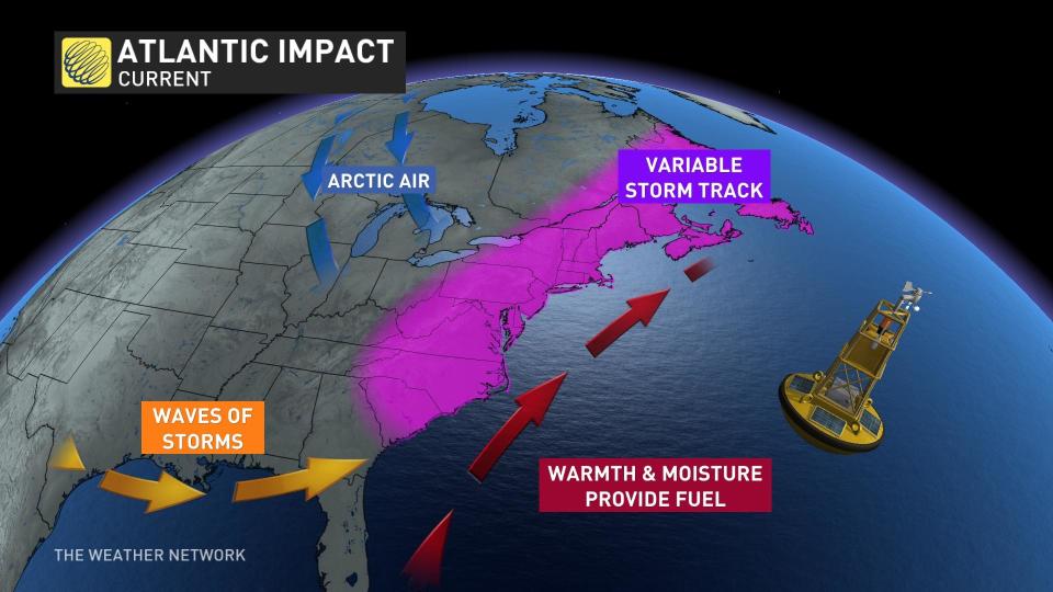
The warm Atlantic could complicate winter storms
One big wild card with this upcoming winter is the very warm water temperatures throughout the Atlantic Ocean.
DON’T MISS: ‘Weather bombs’ are explosive storms that create explosive conditions
We’ve already seen the Atlantic’s influence on the 2023 hurricane season, during which multiple major hurricanes developed despite the presence of El Niño conditions, which typically creates destructive wind shear that stifles Atlantic hurricane activity.
This complex interaction between the two ocean basins could spill over to the winter months, as well. Warmer waters in the western Atlantic Ocean can ‘enhance’ winter storms like nor’easters, providing them a boost in strength that could help produce heavier precipitation and stronger winds.
WATCH: What exactly are El Niño and La Niña?
*****
Credit belongs to : ca.news.yahoo.com