Parts of northern Canada have set records for historic heat this year, including a prolonged stretch of warmth that drove temperatures more than 10°C above normal to start out this month across the north.
So now, with frigid temperatures, signs of snow, and even blizzard conditions in the forecast, it may come as a bit of a shock to the system for some. But it’s also a sign of what’s to come for the country as we head deeper into this fall season.
RELATED: Canada’s Far North saw its hottest temperature ever recorded
On Wednesday, Eureka, a small region in Nunavut, reached a frigid low of -30°C—the first across Canada to do so this season. Temperatures plunged back to a bone-chilling -30.1°C once again on Thursday morning.
Temperatures will “warm up” over the next couple of days, with overnight lows dipping down to -15 to -20°C.
The cold however, while not quite as extreme, is about to make its way to the rest of Canada as we head into the final week of October.
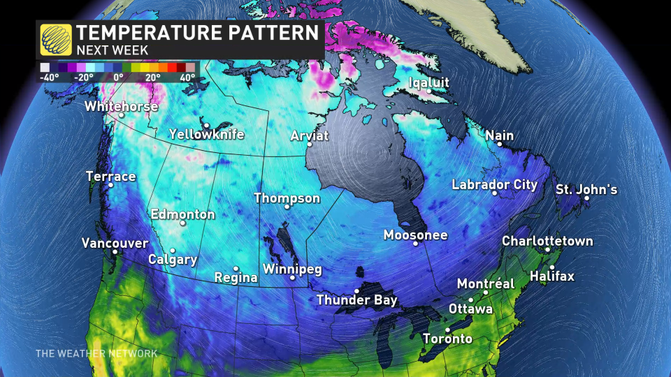
Across B.C., single digit highs are forecast into the middle of next week, with the first frost threat spreading through the Okanagan region.
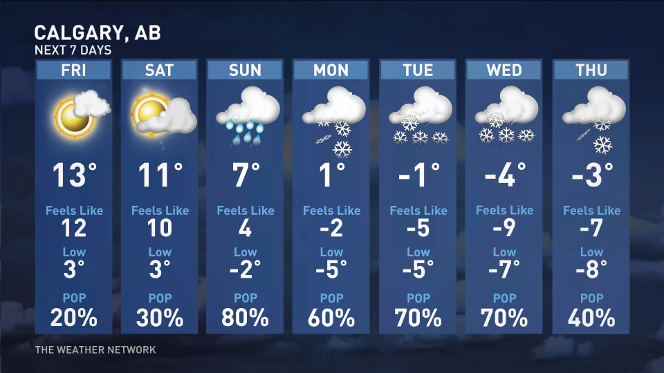
Daytime high temperatures below freezing will take hold as early as Monday for parts of Alberta, with the chill lasting through all of next week. The cooling temperatures will be the perfect recipe for signs of snow in the forecast, after mild temperatures into the mid-20’s spanned the region this week.
Talk about a quick free fall into winter!
 Temperatures won’t be quite as cold as in Alberta, Saskatchewan, and Manitoba, but they’ll eventually reach below freezing during the middle to end of next week. It’s even possible to reach minus-double-digit overnight lows for central areas.
MUST SEE: El Niño’s impact on Canada’s winter: What to expect?
In central Ontario, the first potential single-digit daytime high of the season is expected on Sunday. Some areas in the southwest and the Greater Toronto Area may also see their first frost on Monday morning.

Concerning warmth blasts the Canadian Arctic for the start of October
*****
Credit belongs to : ca.news.yahoo.com