 Back to reality, Ontario. Winter has taken over once again.
The abrupt switch back to winter weather on Wednesday came after rare February thunderstorms in southern Ontario on Tuesday, with some cells even dropping some hail, putting a rare spin on the late-winter day.
RELATED: Rare winter hail pelts southern Ontario communities
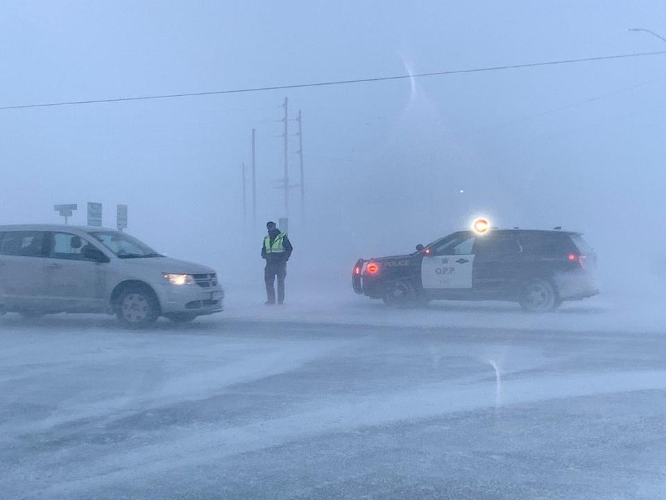
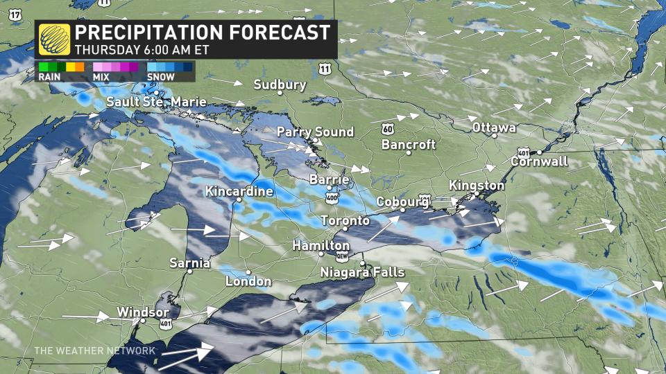
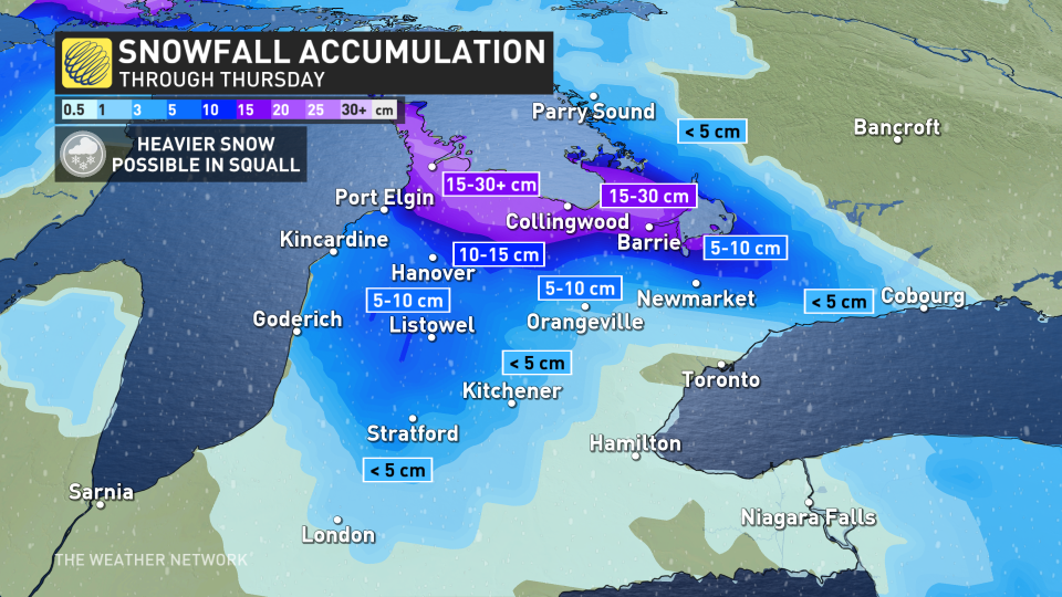
Instead of record-setting warmth and thunderstorms, we now have temperatures that dropped by as much as 15 degrees into the negative digits in a matter of one hour or as much as 20 degrees in a few hours, leading to a flash freeze in many locales, as well as potent snow squalls near Lake Huron and Georgian Bay that threaten to drop as much as 30 cm of snow.
 Snow squall warnings and watches, as well as special weather statements are in place. Some areas could see blizzard-like conditions, so consider postponing non-essential travel until conditions improve.
Recap of the spring-like weather on Tuesday and Wednesday
It doesn’t happen often that Canada’s first severe thunderstorm warning of the year occurred in the early-morning hours on Wednesday (roughly 2:30 a.m. EST).
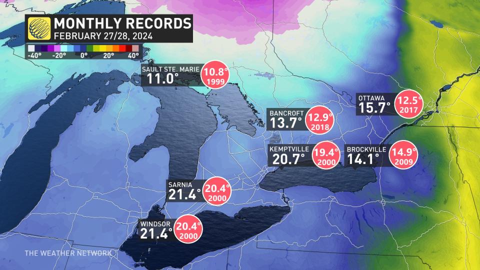
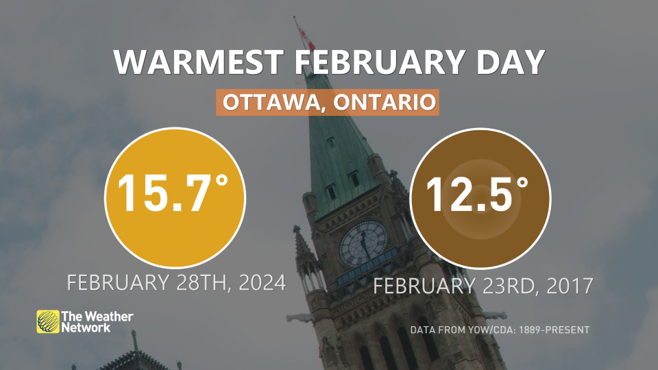
Plus, thanks to the atypical warmth, several Ontario locales recorded their warmest February temperature on record.
 Potential for blizzard-like conditions through Thursday morning with potent squalls
Once the temperatures plummeted, it didn’t take long for the lake-effect machine to kick into high gear as the wind directions changed.
The snow squalls that developed Wednesday evening will continue through Thursday afternoon before ending in the evening. Be aware of sudden icy and snowy surfaces, and adapt your travel plans accordingly.
Travel will extremely difficult and dangerous within the snow squalls, as 60+ km/h winds and snowfall rates near 3 cm an hour will significantly reduce visibility.
A narrow band of intense winter weather will cause havoc on the roads Thursday morning for portions of highways 6 and 10, the Barrie region, and sections of the 400 and 401 east of Toronto. Drivers are urged to consider postponing travel during this time.
Mild weather returns after new all-time record warm February records set
This dramatic switch to winter will be sudden, but also brief. Another extended stretch of exceptionally warm weather will return by Friday across southern Ontario.
Temperatures will soar well above seasonal through this weekend and early next week, with high temperatures more typical of late April and even early May. For many areas, daytime highs will reach the mid- to upper teens. Onshore flow will keep many lake shore areas much cooler, and that will include the GTA at times.
MUST SEE: How global warming is reshaping winter life in Canada
Sarnia also broke its own record high for February on Tuesday, with temperatures climbing to 20.7°C — beating out the previous record of 19.4°C, also set in 2000.
MUST WATCH: Hail, not snow, piles up in Ontario during rare February thunderstorm
Stay with The Weather Network for all the latest on your forecast across Ontario.
*****
Credit belongs to : ca.news.yahoo.com