 El Niño has arrived! That is something we know for certain. But, what does that mean for Canada’s upcoming winter?
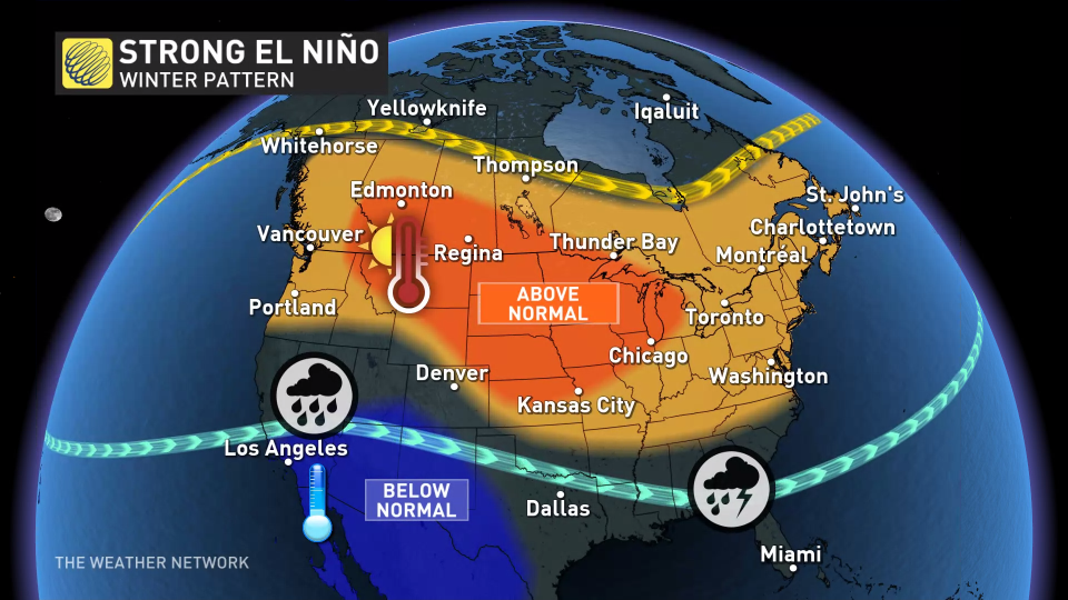
Past data indicates that El Niño winters tend to be relatively mild across the country, particularly during strong El Niño events like the one anticipated for this winter.
Visit our Complete Guide to Fall 2023 for an in-depth look at the Fall Forecast, tips to plan for it and much more!
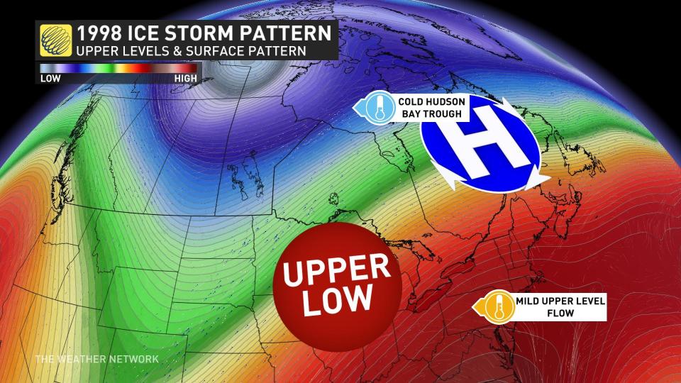
However, even mild winters have a risk for impactful winter weather, as demonstrated by the destructive ice storm that struck southern Quebec and eastern Ontario during the powerful El Niño of 1997-98.
Typically, El Niño winters see an influx of mild Pacific air across most of Canada rather than harsh Arctic air, resulting in a lack of consistent, severe-cold weather.
This winter however, may not play out the same way for a couple of reasons.
 Firstly, the current atmospheric behaviour is not following the script of a typical El Niño event, possibly due to the unusually warm ocean temperatures across the Pacific. Consequently, the expected impact on winter might resemble that of a weak-to-moderate El Niño event rather than a strong one.
DON’T MISS: A ‘historically strong’ El Niño is possible heading into winter
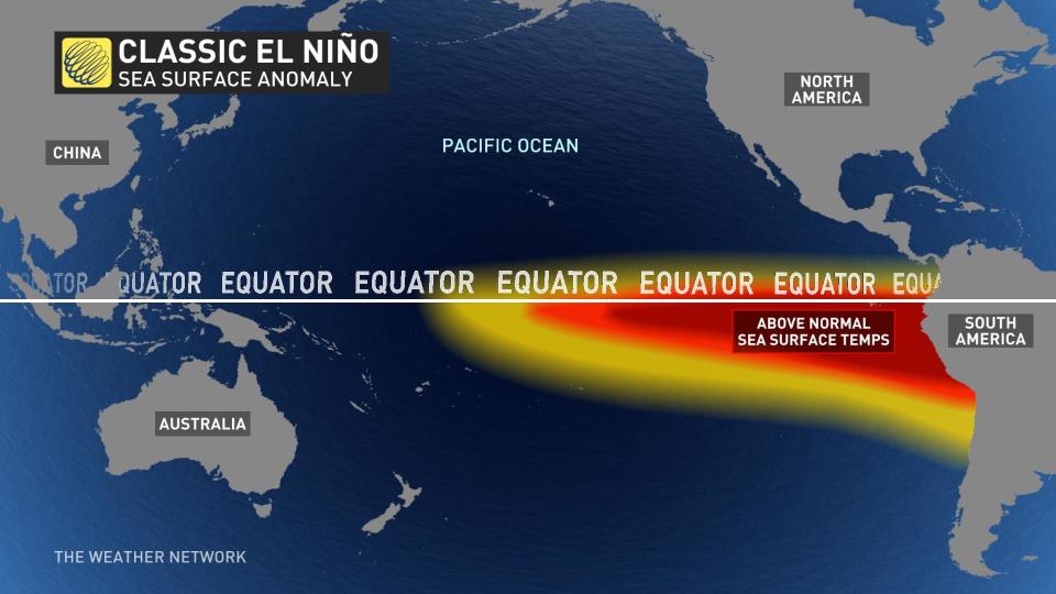
Moreover, historical data shows that the positioning of the warmest temperature anomaly also plays a major role in determining how El Niño will influence the winter pattern.
Currently, the classic El Niño pattern is in place with the warmest sea surface temperature anomalies in the eastern Pacific.
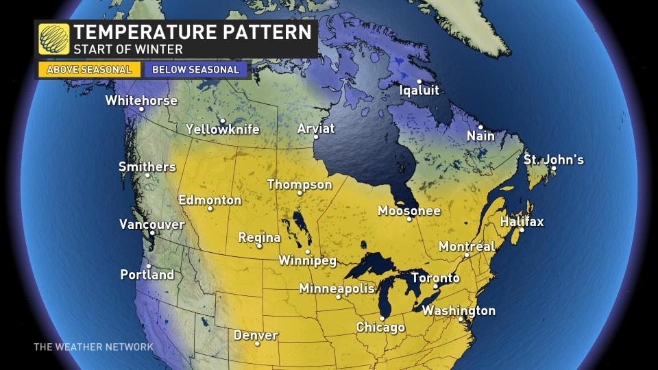
 Therefore, we expect that much of Canada will see a slow start to winter.
Our early winter forecast looks much like what we typically see with a strong and classic El Niño event.
We will see some significant shots of early winter weather, but most of Canada will see a delay in the arrival of consistent cold weather.
 A shift towards a central Pacific-based El Niño (Modoki El Niño) event is expected by the end of winter or early spring 2024.
Why does that matter? Many winters with a central Pacific-based El Niño event have actually featured an abundance of cold winter weather, especially central and eastern Canada.
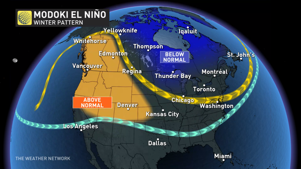
So, the pace of the transition to a central Pacific-based El Niño will significantly shape the national weather pattern during January and February and could be the key to how this winter is remembered, especially across Ontario and Quebec.
If the transition is slow, the early winter pattern will also be the dominant pattern for the season with above above normal temperatures across most of Canada.
Conversely, a rapid transition would dramatically increase the potential for a rather robust finish to winter, featuring more persistent, cold weather later in the season across central and eastern Canada.
As The Weather Network’s official Winter Forecast approaches on Nov. 29, we will monitor the atmosphere’s final alignment with a strong El Niño event, and watch for any movement of the warm sea surface temperature anomaly from the eastern to the central Pacific. Both will be crucial as we refine our final forecast for the upcoming winter.
Check back then to see what’s in store for you!
WATCH: El Niño may lead to more disease outbreaks, here’s why
With files from Tyler Hamilton, a meteorologist at The Weather Network.
*****
Credit belongs to : ca.news.yahoo.com